A to Z GIS | Explore this related guide, featuring updated terms and graphics and developed in coordination with Esri’s GIS Dictionary team.
Learn more about A to Z GIS
GIS Dictionary
Browse dictionary
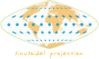
Tissot's indicatrix
URL copiedShare URL
[standards, geodesy]
A graphical representation of the spatial distortion at a particular map location. The indicatrix is the figure that results when a circle on the earth's surface is plotted to the corresponding point on a map. The shape, size, and orientation of an indicatrix at any given point depend on the map projection used. In conformal (shape-preserving) projections, the indicatrix is a circle; in nonconformal projections, it is an ellipse at most locations. As a visual aid, indicatrices convey a general impression of distortion; as mathematical tools, they can be used to quantify distortion of scale and angle precisely. Tissot's indicatrix was devised by French cartographer Nicolas Auguste Tissot (1824 – 1907).