A to Z GIS | Explore this related guide, featuring updated terms and graphics and developed in coordination with Esri’s GIS Dictionary team.
Learn more about A to Z GIS
GIS Dictionary
Browse dictionary
pyramid
URL copiedShare URL
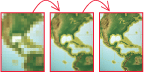
[image processing]
In raster datasets, a method of multiscale image processing that copies the original data in decreasing levels of resolution to enhance performance. The coarsest level of resolution is used to quickly draw the entire dataset; subsequent more detailed layers are drawn at fast speeds, since fewer pixels are required.
[image processing]
A reduced-resolution dataset stored with imagery that is used to read and display imagery at lower resolutions as a means to increase display performance.