A to Z GIS | Explore this related guide, featuring updated terms and graphics and developed in coordination with Esri’s GIS Dictionary team.
Learn more about A to Z GIS
GIS Dictionary
Browse dictionary
resolution
URL copiedShare URL
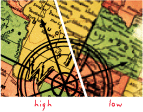
[map design, measurement]
The detail with which a map depicts the location and shape of geographic features. The larger the map scale, the higher the possible resolution. As scale decreases, resolution diminishes and feature boundaries must be smoothed, simplified, or not shown at all; for example, small areas may have to be represented as points.
[image processing]
The dimension of each cell or pixel in raster data that represents the area covered on the ground. Often used interchangeably with spatial resolution.
[image processing, measurement]
The smallest spacing between two display elements, expressed as dots per inch, pixels per line, or lines per millimeter.
[spatial analysis]
The smallest allowable separation between two coordinate values in a feature class. A spatial reference can include x, y, z, and m resolution values. The inverse of a resolution value was previously known as a precision or scale value.