A to Z GIS | Explore this related guide, featuring updated terms and graphics and developed in coordination with Esri’s GIS Dictionary team.
Learn more about A to Z GIS
GIS Dictionary
Browse dictionary
latitude-longitude
URL copiedShare URL
[geodesy, measurement]
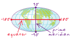
A reference system used to locate positions on the earth's surface. Distances east–west are measured with lines of longitude (also called meridians), which run north–south and converge at the north and south poles. Distance measurements begin at the prime meridian and are measured positively 180 degrees to the east and negatively 180 degrees to the west. Distances north–south are measured with lines of latitude (also called parallels), which run east–west. Distance measurements begin at the equator and are measured positively 90 degrees to the north and negatively 90 degrees to the south.