A to Z GIS | Explore this related guide, featuring updated terms and graphics and developed in coordination with Esri’s GIS Dictionary team.
Learn more about A to Z GIS
GIS Dictionary
Browse dictionary
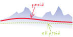
geoid
URL copiedShare URL
[geodesy]
The equipotential surface of the earth's gravity field that coincides with the mean sea level of the unperturbed oceans. The geoid is used as a reference surface for measuring gravity-based heights (orthometric, normal, and dynamic).