A to Z GIS | Explore this related guide, featuring updated terms and graphics and developed in coordination with Esri’s GIS Dictionary team.
Learn more about A to Z GIS
GIS Dictionary
Browse dictionary
conformal projection
URL copiedShare URL
[map projections]
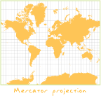
A map projection that preserves the relative proportions and angles of small areas. In a conformal projection, graticule lines intersect at 90-degree angles, and at any point on the map the scale is the same in all directions. A conformal projection maintains all angles at each point, including those between the intersections of arcs; therefore, the size of areas enclosed by many arcs may be distorted. Conformal projections are particularly useful for mapping coastlines, boundaries, or other detailed features. Examples of conformal projections include the Mercator projection, the Lambert conformal conic projection, and the transverse Mercator projection.