CÓMO
Calcular NDVI para varias imágenes de satélite utilizando una fórmula aritmética de banda en ArcGIS Pro
Resumen
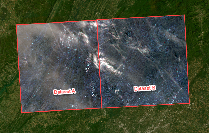
El índice de vegetación con diferencia normalizada (NDVI) es un método utilizado en el análisis de la vegetación para evaluar la degradación de la tierra a lo largo del tiempo, la biomasa verde o la salud de la vegetación. El índice se determina comparando la absorción del pigmento clorofila en la banda roja y la elevada reflectividad del material vegetal en la banda del infrarrojo cercano, que es captada por instrumentos de teledetección como satélites o drones. En ArcGIS Pro, la función Aritmética de banda permite el cálculo de NDVI mediante una fórmula aritmética de banda. Este método crea una nueva banda de salida, que permite extraer información significativa de las propiedades espectrales para un análisis o una visualización en profundidad. El flujo de trabajo proporcionado en este artículo implica la creación de rásteres multibanda a partir de bandas individuales de las imágenes de satélite Sentinel-2 Level-2A, como se muestra en la imagen siguiente.
A continuación, se crea un mosaico de los rásteres multibanda y se utilizan como entrada para calcular el NDVI usando la fórmula aritmética de banda específica de las imágenes de satélite Sentinel-2 Level-2A.
Procedimiento
Note:
Individual files of bands are used to represent different types of satellite imagery. For example, the Sentinel-2 Level-2A satellite imagery includes a Multi-Spectral Instrument (MSI) with 13 spectral bands and pixel resolutions ranging from 10 to 60 meters. Refer to ArcGIS Pro: Sentinel-2 for more information. To enhance data visualization and interpretation, the imagery bands must be combined into a single raster dataset containing multiple bands prior to mosaicking. The band combination is determined by the analysis objectives and the characteristics of the target area.
- Abra el proyecto en ArcGIS Pro.
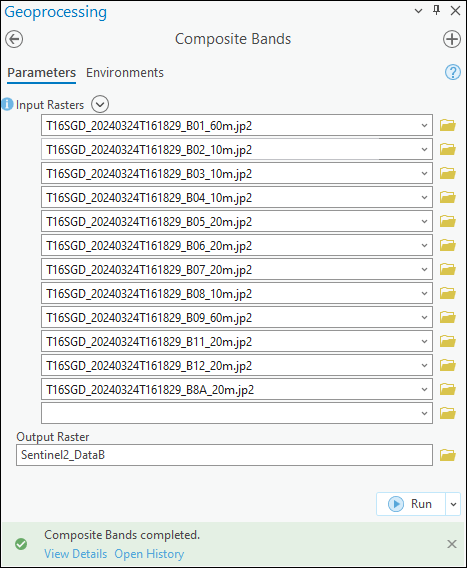
- Cree un ráster multibanda a partir de las bandas individuales de las imágenes de satélite. Consulte Cómo: Crear un ráster multibanda a partir de bandas individuales de imágenes de satélite en ArcGIS Pro para obtener instrucciones. En este ejemplo, se crean dos rásteres multibanda denominados Sentinel2_DataA y Sentinel2_DataB con la herramienta Bandas compuestas.
- En la pestaña Vista, en el grupo Ventanas, haga clic en Panel Catálogo.
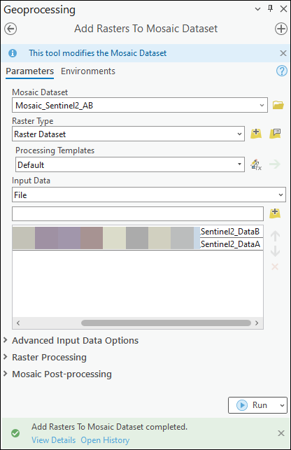
- Cree un dataset de mosaico y agregue los rásteres multibanda creados en el paso 2. En este ejemplo, se crea el dataset de mosaico denominado Mosaic_Sentinel2_AB.
Note:
In ArcGIS Pro, the Band Arithmetic function can only perform an arithmetic operation on a single raster layer at a time, which is a known limitation. However, mosaicking multiple raster datasets into a single raster dataset allows the NDVI of the imagery to be calculated across the entire dataset.
- Calcule el NDVI de las imágenes utilizando la fórmula aritmética de banda.
Note:
Satellite imagery includes bands representing different wavelengths of the electromagnetic spectrum, ranging from ultraviolet to visible, near infrared, and shortwave infrared. Refer to ArcGIS Pro: Raster bands for more information. Ensure the band arithmetic formula includes the correct band combination for the imagery before calculating the NDVI.
- En la pestaña Imágenes, en el grupo Análisis, haga clic en Funciones ráster.
- En el panel Funciones ráster, en Matemáticas, haga clic en Aritmética de banda.
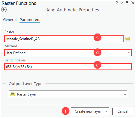
- En el panel Propiedades aritméticas de banda, en Ráster, seleccione el dataset de mosaico creado en el paso 4 en la lista desplegable.
- En Método, seleccione Definido por el usuario en la lista desplegable.
- Para Índices de banda, copie la siguiente fórmula aritmética de banda para NDVI y péguela en el cuadro Índices de banda. Reemplace <NIR> por la banda de infrarrojo cercano preferida y <Red> por la banda roja de las imágenes. En este ejemplo, B8 (banda 8) representa la banda del infrarrojo cercano y B4 (banda 4) representa la banda roja de las imágenes de satélite Sentinel-2 Level-2A.
(<NIR>-<Red>)/(<NIR>+<Red>)
- Haga clic en Crear una nueva capa.
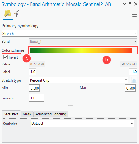
- Cambie el esquema de color de la capa NDVI para distinguir claramente la densidad de la vegetación.
- En el panel Contenido, haga clic con el botón derecho en la capa NDVI y haga clic en Simbología.
- En el panel Simbología, en Esquema de color, seleccione el esquema de color preferido en la lista desplegable. En este ejemplo, el esquema de color Número de condición se selecciona para mostrar colores de verde a rojo. Active la casilla de verificación Mostrar nombres para mostrar los nombres descriptivos de todos los esquemas de color, si es necesario.
- Active la casilla de verificación Invertir para invertir los colores, si es necesario.
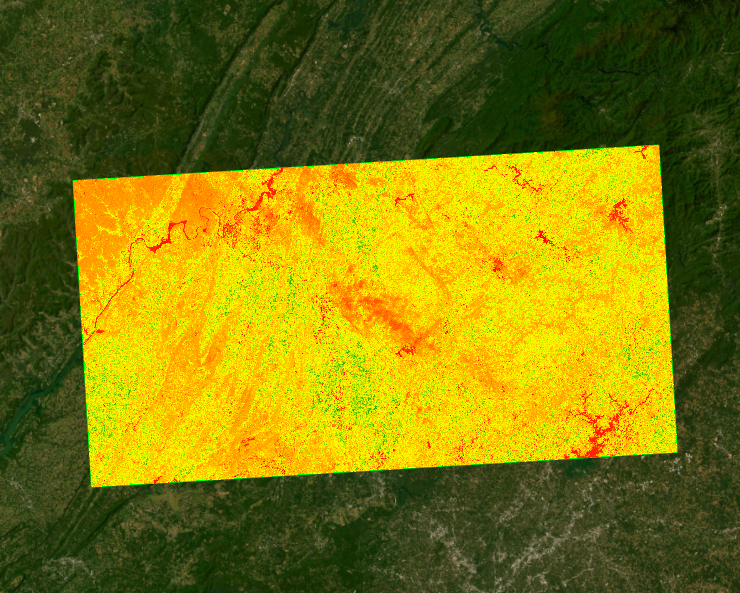
La siguiente imagen muestra el NDVI correspondiente a las imágenes de Sentinel-2 múltiples calculadas utilizando la fórmula aritmética de banda en ArcGIS Pro. Los valores NDVI (debajo de la capa ráster en el panel Contenido) oscilan entre -1 y 1, y los valores más altos indican una vegetación más sana y abundante.
Id. de artículo: 000032331
Obtenga soporte con IA
Resuelva su problema rápidamente con el chatbot de inteligencia artificial de soporte de Esri.


Información relacionada
Descubrir más sobre este tema
Search for related information
Find training related to this topic
Explore ideas and give feedback
Obtener ayuda de expertos en ArcGIS
Empieza a chatear ahora