A to Z GIS | Explore this related guide, featuring updated terms and graphics and developed in coordination with Esri’s GIS Dictionary team.
Learn more about A to Z GIS
GIS Dictionary
Browse dictionary
arc
URL copiedShare URL
[geometry]
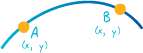
On a map, a shape defined by a connected series of unique x,y coordinate pairs. An arc may be straight or curved.
[geometry]
A coverage feature class that represents lines and polygon boundaries. One line feature can contain many arcs. Arcs are topologically linked to nodes and to polygons.