PROBLEM
Unable to add GNSS metadata in ArcGIS Pro
Description
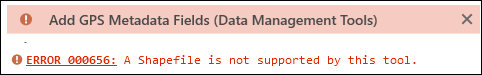
ArcGIS Field Maps and ArcGIS Collector both require Global Navigation Satellite System (GNSS) metadata to improve the accuracy and reliability of GPS data captured, such as ground control points. In ArcGIS Pro, adding the GNSS metadata to the shapefile exported from the hosted feature layer in ArcGIS Online returns the following error message:
Error:
ERROR 000656: A Shapefile is not supported by this tool.
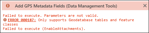
In some instances, adding GNSS metadata to the hosted feature layer in ArcGIS Pro returns the following error message:
Error:
ERROR 000187: Only supports Geodatabase tables and feature classes
Cause
The Add GPS Metadata Fields tool does not support hosted feature layers and shapefiles. This tool can only be used with the file geodatabase feature class and tables.
Solution or Workaround
Export the hosted feature layer to a file geodatabase from ArcGIS Online
In ArcGIS Online, export the hosted feature layer as a file geodatabase instead of a shapefile. Refer to FAQ: Is it possible to export feature collections to a file geodatabase directly in ArcGIS Online? for instructions. The downloaded file geodatabase can then be imported to the ArcGIS Pro map to add the GNSS metadata using the Add GPS Metadata Fields tool.
Export the hosted feature layer to a file geodatabase feature class in ArcGIS Pro
In ArcGIS Pro, use the portal connection to add the hosted feature layer to the map. Refer to How To: Export a feature service to a file geodatabase feature class in ArcGIS Pro for instructions. Subsequently, convert the feature layer to a file geodatabase feature class and add the GNSS metadata using the Add GPS Metadata Fields tool.
Convert the shapefile to a file geodatabase feature class in ArcGIS Pro
If the data is a shapefile, use geoprocessing tools in ArcGIS Pro to convert it to a file geodatabase . Refer to How To: Export selected features from a feature layer in ArcGIS Pro for instructions. The GNSS metadata can then be added to the output feature layer using the Add GPS Metadata Fields tool.
Article ID: 000033740
- ArcGIS Online
- ArcGIS Pro 3 1
- ArcGIS Pro 3 3
- ArcGIS Field Maps Android
- ArcGIS Field Maps iOS
- ArcGIS Pro 3 2
Get support with AI
Resolve your issue quickly with the Esri Support AI Chatbot.


Related Information
Discover more on this topic
Search for related information
Find training related to this topic
Explore ideas and give feedback
Get help from ArcGIS experts
Start chatting now