PROBLEM
The GPS metadata fields are empty when creating data in ArcGIS Field Maps
Description
When collecting and creating data in the ArcGIS Field Maps mobile app, the GPS metadata fields are empty. ArcGIS Field Maps cannot record the latitude, longitude, altitude, and other GPS metadata values for certain features, despite the GPS receiver functioning correctly and transmitting data. The inability to record the GPS metadata impacts the accuracy and usability of the collected spatial data.
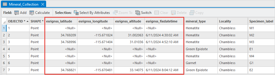
The attribute table below shows the empty GPS metadata fields for certain data collected in ArcGIS Field Maps.
Cause
- The point features are manually repositioned away from the coordinates provided by the GPS signal.
- The point features are snapped to another existing point.
Solution or Workaround
To record the GPS metadata accurately, configure the ‘Manual location’ or ‘Snapping’ settings when preparing the map in ArcGIS Field Maps Designer or within the ArcGIS Field Maps mobile app.
Disable manual location entry during data collection in ArcGIS Field Maps Designer
- Log in to ArcGIS Field Maps Designer via ArcGIS Online.
- On the Maps page, browse to and click the map card.
- On the left of the page, click App settings > Collection.
- In the Collection section, under Manual location, select Block manual location.
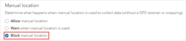
- Click Save changes
 on the top-right corner of the page.
Disable feature snapping in ArcGIS Field Maps Designer
- Log in to ArcGIS Field Maps Designer via ArcGIS Online.
- On the Maps page, browse to and click the map card.
- On the left of the page, click App settings > Collection.
- In the Collection section, toggle Snapping off to disable snapping.
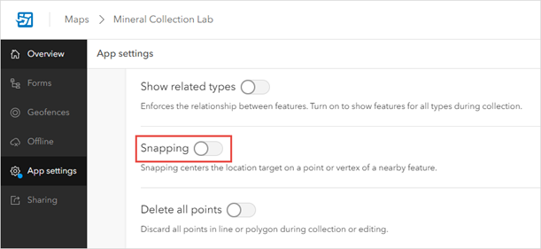
- Click Save changes
 on the top-right corner of the page.
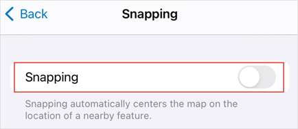
Disable feature snapping in the ArcGIS Field Maps mobile app
- Log in to the ArcGIS Field Maps mobile app via ArcGIS Online.
- On the top-left corner, tap Profile
 .
. - Tap Collection Settings > Snapping.
- Toggle Snapping off to disable snapping.
Article ID: 000032464
- ArcGIS Field Maps Android
- ArcGIS Field Maps iOS
Get support with AI
Resolve your issue quickly with the Esri Support AI Chatbot.


Related Information
Discover more on this topic
Search for related information
Find training related to this topic
Explore ideas and give feedback
Get help from ArcGIS experts
Start chatting now