HOW TO
Perform a viewshed analysis when elevation data for the area of interest is unavailable
Summary
In some cases, when performing a viewshed analysis on a feature, the elevation data for the area of interest is unavailable. However, it is possible to run the analysis by using the Viewshed tool from the Ready-To-Use Services in ArcMap.
Note:
The tool consumes one (1) credit for every 1,000 input features.
The following instructions describe how to perform a viewshed analysis without elevation data.
Procedure
- In ArcMap, ensure the observer points are in the correct location by adding the point dataset to the map.
Note:
If the point data is in an Excel file, refer to Adding x,y coordinate data as a layer to import and display the points on the map.
- Sign in to an ArcGIS Online organizational account.
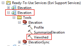
- Run the Viewshed tool from the Ready-To-Use Services in the Catalog pane.
- Expand Ready-To-Use Services and select the second option for Elevation.
- Expand Tools > Elevation > Viewshed.
- Set the point dataset from Step 1 as the input point feature.
- Click OK. A new layer is created in the Table of Contents.
- Export the output layer to a feature class.
Note:
The output layer from the Viewshed tool is a temporary polygon layer. To make the layer a permanent layer, the data must be exported.
Article ID: 000018209
Software:
- ArcMap
- ArcGIS Pro
- ArcGIS Online
Get support with AI
Resolve your issue quickly with the Esri Support AI Chatbot.


Related Information
Discover more on this topic
Search for related information
Find training related to this topic
Explore ideas and give feedback
Get help from ArcGIS experts
Start chatting now