HOW TO
Publish a multiscale contour map to ArcGIS Online
Summary
Contours are the primary element used to represent elevation on topographic maps. The high density of interval information between fixed-scale contours sometimes requires the use of a dynamic map that displays the data at multiple scales. Multiple scales are useful when interpreting detailed, large-scale contour maps such as a national topographic map. In ArcGIS Pro, the appropriate, visible scale range can be specified for each contour level using the Out Beyond and In Beyond scale range properties. This method ensures only the data required for a significant contour map and the appropriate density are included at each scale.
The workflow provided in this article involves creating a multiscale mesh of polygons using the Create Vector Tile Index tool. The tile index is then used for the Index Polygons parameter when publishing the vector tile packages to ArcGIS Online.
Procedure
- Open the project in ArcGIS Pro.
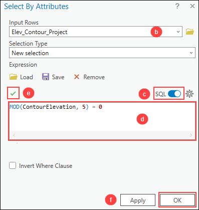
- Select features from the contour feature layer using the Select By Attributes tool.
- On the Map tab, in the Selection group, click Select By Attributes
 .
. - In the Select By Attributes dialog box, for Input Rows, select the contour feature layer from the drop-down list.
- Toggle SQL on to open the SQL expression box.
- Copy the following query expression and paste it in the Expression box. Replace <field name> with the elevation field name, and <interval> with the preferred contour interval.
MOD(<field name>,<interval>) = 0
- Click Verify
 to validate the expression.
 - Click OK.
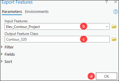
- Export the selected feature class using the Export Features tool.
- On the Contents pane, right-click the contour feature layer. Click Data > Export Features.
- In the Export Features window, for Input Features, select the contour feature layer from the drop-down list.
- For Output Feature Class, specify a location and name to export the feature class.
- Click OK.
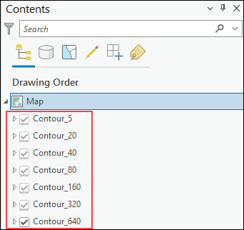
- Repeat Steps 2 and 3 to create a separate feature layer for each contour interval.
- Simplify the contour interval feature layers using the Generalize tool. Refer to the Procedure section of How To: Reduce the number of polygon vertices in ArcGIS Pro for instructions.
Note:
Select the contour interval feature layer for Input Features. Repeat Step 5 to simplify each contour interval feature layer.
- Set the visible scale range for each contour interval feature layer. Refer to the ‘Limit the scale range of a layer’ section of ArcGIS Pro: Adjust layer properties for instructions.
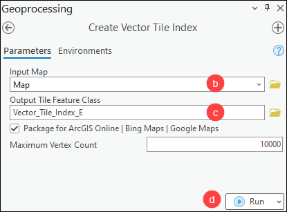
- Create index polygons for the vector tile package using the Create Vector Tile Index tool.
Note:
Remove any basemap layers from the Contents pane before running the Create Vector Tile Index tool.
- In the Geoprocessing pane, search for and click Create Vector Tile Index (Data Management Tools).
- For Input Map, select the map layer from the drop-down list.
- For Output Tile Feature Class, specify a name and location to export the feature class.
- Click Run.
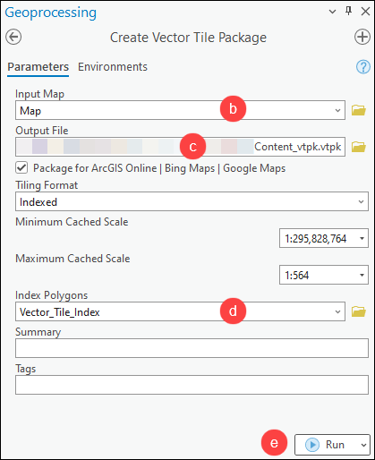
- Create the vector tiles and package the tiles in a single file using the Create Vector Tile Package tool.
Note:
All map packages must have a description. It can be added by editing the map’s metadata and populating the appropriate fields. Refer to ArcGIS Pro: Edit metadata for more information.
- In the Geoprocessing pane, search for and click Create Vector Tile Package (Data Management Tools).
- In the Create Vector Tile Package pane, for Input Map, select the map layer from the drop-down list.
- For Output File, specify a location and name to export the output vector tile package.
- For Index Polygons, select the index polygon layer from the drop-down list.
- Click Run.
- In ArcGIS Online, add the vector tile package and publish its contents as a hosted vector tile layer. Refer to ArcGIS Online: Build and publish a vector tile package for instructions and more information.
The map below shows the published hosted vector tile layer in ArcGIS Online.

Article ID: 000030922
- ArcGIS Online
- ArcGIS Pro 3 1
- ArcGIS Pro 3 0
- ArcGIS Pro 2 9x
Get support with AI
Resolve your issue quickly with the Esri Support AI Chatbot.


Related Information
Discover more on this topic
Search for related information
Find training related to this topic
Explore ideas and give feedback
Get help from ArcGIS experts
Start chatting now