HOW TO
Convert 2D features to 3D features using geoprocessing tools in ArcGIS Pro
Summary
In ArcGIS Pro, 2D features can be converted to 3D features by adding z-values to the geometry using three different geoprocessing tools, depending on the conversion goal and the data available.
This article provides three methods to convert existing 2D features to 3D features using geoprocessing tools in ArcGIS Pro: deriving z-values from attribute values, interpolating z-values using a surface layer, and extruding features between surfaces.
Procedure
Note:
Access to these tools requires the 3D Analyst license. Refer to ArcGIS Pro: Enable ArcGIS 3D Analyst extension for more information.
Deriving z-values from attribute values
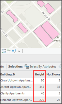
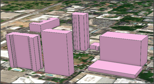
If the z-values of features, such as height values, are available as attributes of the 2D feature dataset, the attributes can be used to create 3D features using the Feature To 3D By Attribute tool. The image below shows 2D polygons with a Height field in the attribute table.
- Open the project containing the 2D feature layer in ArcGIS Pro.
- Convert the 2D feature layer using the Feature To 3D By Attribute tool.
- On the ribbon, click Analysis and click Tools.
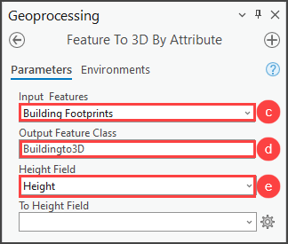
- In the Geoprocessing pane, search for and select Feature To 3D By Attribute (3D Analyst Tools).
- Select the 2D feature layer for Input Features.
- Specify the output for Output Feature Class.
- Click the Height Field drop-down arrow to select the elevation value field and click Run.
- Create a new local scene and add the 3D feature layer to the scene. Refer to ArcGIS Pro: Create a scene and ArcGIS Pro: Add data to a project for more information.
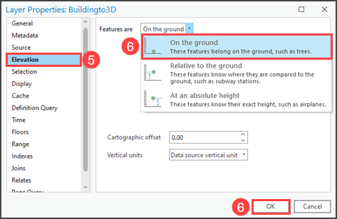
- Right-click the 3D feature layer in the Contents pane and click Properties.
- In the Layer Properties dialog box, click Elevation.
- Set Features are to On the ground, and click OK.
- Extrude the 3D feature layer.
- Select the layer in the Contents pane.
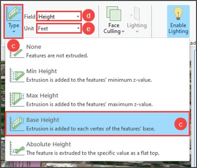
- Click Feature Layer on the ribbon.
- In the Extrusion group, click the Type drop-down arrow and select Base Height. Refer to ArcGIS Pro: Extrude features for more feature extrusion types.
- For Field, select the elevation value field.
- For Unit, select the unit of measurement.
Interpolating z-values using a surface layer
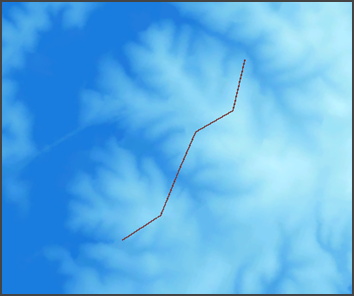
If an underlying elevation surface, such as a raster, TIN, or terrain surface, on which the 2D features reside is available, the Interpolate Shape tool can be used to interpolate z-values for the 2D features from the elevation surface. The image below shows a 2D line feature, representing a bridge, on a raster surface layer.
- Open the scene in ArcGIS Pro.
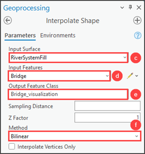
- Convert the 2D feature using the Interpolate Shape tool.
- On the ribbon, click Analysis and click Tools.
- In the Geoprocessing pane, search for and select Interpolate Shape (3D Analyst Tools).
- Select the surface layer for Input Surface.
- Select the 2D feature for Input Features.
- Specify the output for Output Feature Class.
- Click the Method drop-down arrow and select an interpolation method. In this example, Bilinear is selected. Refer to ArcGIS Pro: Parameters for more interpolation methods.
- Click Run.
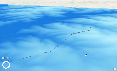
The image below shows the Bridge line feature raised by the elevations of the raster surface layer underneath.
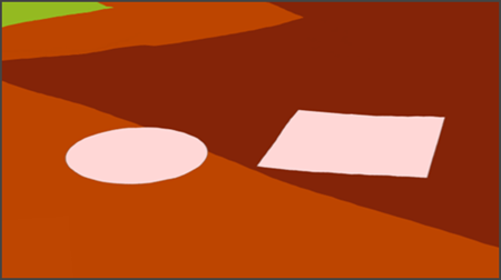
Extruding features between surfaces
If a 2D feature is situated between two surfaces, the feature can be extruded between the two surfaces using the Extrude Between tool. For example, a mining company can create subsurface blocks between the summit of hills and subsoil surfaces to study an area’s underground geological horizon.
Note:
The Extrude Between tool requires TIN surfaces as inputs. Refer to ArcGIS Pro: TIN in ArcGIS Pro  for more information.
The image below shows two polygon features representing study areas to be extruded between a ground surface TIN layer, and a subsurface TIN layer.
- Open the scene in ArcGIS Pro.
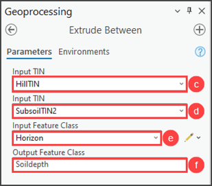
- Extrude the 2D feature using the Extrude Between tool.
- On the ribbon, click Analysis and click Tools.
- In the Geoprocessing pane, search for and select Extrude Between (3D Analyst Tools).
- Select one of the two surface layers for Input TIN.
- Select the other surface layer for Input TIN.
- Select the 2D feature for Input Feature Class.
- Specify the output for Output Feature Class, and click Run.
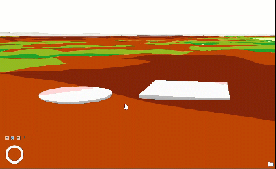
The image below shows the 2D polygon features extruded between the ground surface TIN layer and subsurface TIN layer to display the area of study in 3D.
Article ID: 000030196
- ArcGIS Pro 3 1
- ArcGIS Pro 3 0
- ArcGIS Pro 2 x
Get support with AI
Resolve your issue quickly with the Esri Support AI Chatbot.


Related Information
Discover more on this topic
Search for related information
Find training related to this topic
Explore ideas and give feedback
Get help from ArcGIS experts
Start chatting now