HOW TO
Calculate the area percentage and count of joined features within buffer zones in ArcGIS Pro
Summary
In ArcGIS Pro, calculating the area percentage and feature count of joined polygon features within buffer zones is a spatial analysis technique for understanding the spatial distribution of features relative to a central location. Quantifying the spatial distribution of features across distance zones provides valuable insights for making location-based decisions. This article describes the workflow to calculate the area percentage and count of joined features within buffer zones in ArcGIS Pro.
Procedure
- Open the ArcGIS Pro project with two polygon feature layers. In this example, the polygon feature layers are Polygon1 and Polygon2.
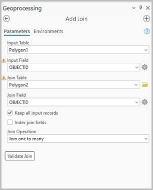
- Join the two polygon feature layers based on the common field using the Add Join tool.
- On the Analysis tab, in the Geoprocessing group, click Tools.
- In the Geoprocessing pane, search for and select Add Join (Data Management Tools).
- In the Add Join pane, select the feature layer for the Input Table drop-down list. In this example, Polygon1 is selected.
- For Input Field, select the preferred field of the input layer. In this example, OBJECTID is selected.
- For Join Table, select the feature layer to be joined. In this example, Polygon2 is selected.
- For Join Field, select the preferred field of the join layer. In this example, OBJECTID is selected.
- For Join Operation, select Join one to many.
- Click Run.
Note:
Run the Select Layer By Attribute tool if exporting only selected features.
- Run the Export Features tool to export the joined feature layer.
- Select a preferred polygon feature on the map to be buffered. Refer to ArcGIS Pro: Select features for instructions.
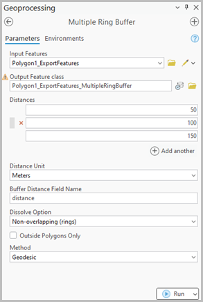
- Run the Multiple Ring Buffer tool to create zone ranges for a selected polygon feature in the joined feature layer.
- In the Geoprocessing pane, search for and select Multiple Ring Buffer (Analysis Tools).
- In the Multiple Ring Buffer pane, for Input Features, select the output feature layer from Step 3.
- For Output Feature class, specify a name and location.
- For Distances, specify the buffer distances. In this example, the distance is 50.
- Click Add another to add another buffer distance if necessary. In this example, 100 and 150 are added.
- For Distance Unit, select the buffer linear unit. In this example, Meters is selected.
- Click Run.
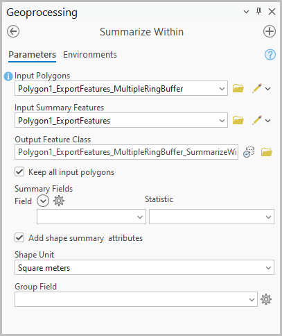
- Summarize the number of polygons within the buffer zones using the Summarize Within tool.
- In the Geoprocessing pane, search for and select Summarize Within (Analysis Tools).
- In the Summarize Within pane, for Input Polygons, select the output feature layer from Step 5.
- For Input Summary Features, select the joined feature layer. In this example, Polygon1_ExportFeatures is selected.
- Disable the Use the selected records option if necessary.
- For Output Feature Class, specify a name and location.
- For Shape Unit, specify the unit to calculate the shape summary attributes. In this example, Square meters is selected.
- Click Run.
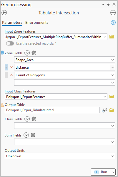
- Calculate the area and percentage of the joined features within the buffer zones using the Tabulate Intersection tool. Refer to How To: Calculate the percentage of intersecting polygon areas in ArcGIS Pro for instructions. For Zone Fields, select the Shape_Area, distance, and 'Count of Polygons' fields.
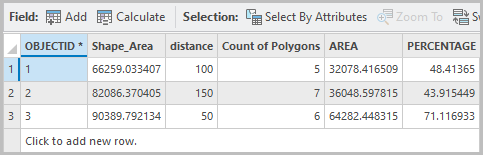
The attribute table below shows the counts and area percentages of the joined features within the buffer zones.
Article ID: 000036936
- ArcGIS Pro
Get support with AI
Resolve your issue quickly with the Esri Support AI Chatbot.


Related Information
Discover more on this topic
Search for related information
Find training related to this topic
Explore ideas and give feedback
Get help from ArcGIS experts
Start chatting now