HOW TO
Identify intersecting features within a buffer distance in ArcGIS Pro
Summary
Identifying features intersecting a buffer within a specified distance is crucial for disaster response and risk assessment. This approach improves risk evaluation by identifying vulnerable areas for effective disaster mitigation planning. This article provides two workflows in ArcGIS Pro to identify intersecting features within a buffer for more precise area assessments.
Procedure
Use the Overlay Layers tool
Note:
For instructions to find and use the geoprocessing tool, refer to ArcGIS Pro: Find a geoprocessing tool.
- Open the ArcGIS Pro project.
- Create a buffer zone around a preferred point feature using the Create Buffers tool. This tool requires the ArcGIS Pro Advanced license.
- In the Create Buffers pane, for Input Layer, select the point feature layer from the drop-down list.
- For Output Feature Class, specify a name and location.
- For Buffer Distance, set a distance and unit of measurement for the buffer.
- Click Run.
- Identify the intersecting features within the buffer zone using the Overlay Layers tool.
- In the Overlay Layers pane, for Input Layer, select the buffer layer from Step 2 from the drop-down list.
- For Overlay Layer, select the feature layer to be overlaid with the buffer. In this example, a polygon feature layer is selected.
- For Output Feature Class, specify a name and location.
- For Overlay Type, ensure Intersect is selected.
- Click Run.
Use the Intersect tool
Note:
For instructions to find and use the geoprocessing tool, refer to ArcGIS Pro: Find a geoprocessing tool.
- Follow Steps 1 through 2 from the method above to create a buffer zone.
- Find the intersecting features within the buffer zone using the Intersect tool.
- In the Intersect pane, for Input Features, select the buffer layer from Step 1 along with other layers to be intersected. In this example, the buffer layer and a polygon feature layer are selected.
- For Output Feature Class, specify a name and location.
- Click Run
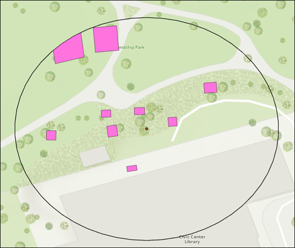
The map below shows the polygon features and the intersecting parts within the buffer zone.
Article ID: 000034923
- ArcGIS Pro 3 3
- ArcGIS Pro 3 2
- ArcGIS Pro 3 4
Get support with AI
Resolve your issue quickly with the Esri Support AI Chatbot.


Related Information
Discover more on this topic
Search for related information
Find training related to this topic
Explore ideas and give feedback
Get help from ArcGIS experts
Start chatting now