HOW TO
Calculate longitude and latitude in decimal degrees in ArcGIS Pro
Summary
Latitude and longitude coordinates are expressed in degrees, minutes, seconds (DMS), or decimal degrees (DD). Decimal degrees make digital storage of coordinates easier and computations faster. This article highlights the workflow to calculate longitude and latitude in decimal degrees in ArcGIS Pro by using the Calculate Geometry Attributes tool.
Procedure
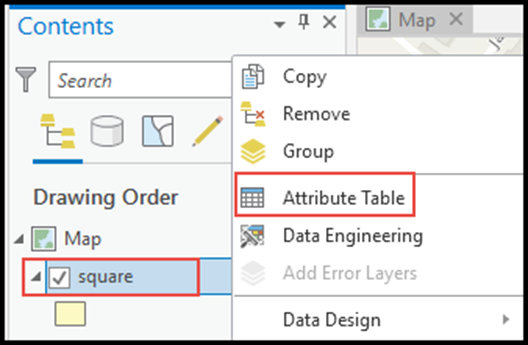
- In ArcGIS Pro, in the Contents pane, select and right-click the feature layer, and click Attribute Table to view the attribute table pane.
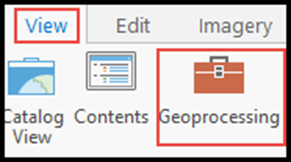
- Navigate to the top ribbon, and click View > Geoprocessing.
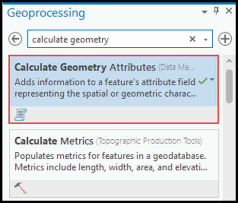
- In the Geoprocessing pane, search for and select the Calculate Geometry Attributes tool.
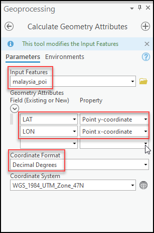
- Under Parameters, select the layer for Input Features.
- Under Geometry Attributes Field (Existing or New), select the desired fields or create new fields for the latitude and longitude values and the properties by clicking the drop-down box under Property. Specify Point y-coordinate for latitude, and Point x-coordinate for longitude.
- Under Coordinate Format, select Decimal Degrees from the drop-down box.
- Specify the coordinate system of the layer selected in Step 4 for Coordinate System. In this example, it is WGS_1984_UTM_Zone_47N, and click Run.
Article ID: 000026403
Software:
- ArcGIS Pro 2 x
Get support with AI
Resolve your issue quickly with the Esri Support AI Chatbot.


Related Information
Discover more on this topic
Search for related information
Find training related to this topic
Explore ideas and give feedback
Get help from ArcGIS experts
Start chatting now