A to Z GIS | Explore this related guide, featuring updated terms and graphics and developed in coordination with Esri’s GIS Dictionary team.
Learn more about A to Z GIS
GIS Dictionary
Browse dictionary
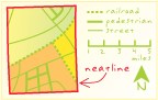
neatline
URL copiedShare URL
[map design]
The border delineating and defining the extent of geographic data on a map. It demarcates map units so that, depending on the map projection, the neatline does not always have 90-degree corners. In a properly made map, it is the most accurate element of the data; other map features may be moved slightly or exaggerated for generalization or readability, but the neatline is never adjusted.