A to Z GIS | Explore this related guide, featuring updated terms and graphics and developed in coordination with Esri’s GIS Dictionary team.
Learn more about A to Z GIS
GIS Dictionary
Browse dictionary
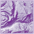
hillshading
URL copiedShare URL
[visualization techniques]
A technique used to enhance the three-dimensional appearance of terrain features that create patterns of light and shadow on the landscape. Illumination is from a simulated light source at a specified azimuth and altitude (typically the map's upper left corner). Hillshading provides a sense of topographic relief of the landscape and a relative measure of incident light for analysis.