A to Z GIS | Explore this related guide, featuring updated terms and graphics and developed in coordination with Esri’s GIS Dictionary team.
Learn more about A to Z GIS
GIS Dictionary
Browse dictionary
equidistant projection
URL copiedShare URL
[map projections]
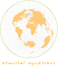
A projection that maintains scale along one or more lines, or from one or two points to all other points on the map. Lines along which scale (distance) is correct are the same proportional length as the lines they reference on the globe. In the sinusoidal projections, for example, the central meridian and all parallels are their true lengths. An azimuthal equidistant projection centered on Chicago shows the correct distance between Chicago and any other point on the projection but not between any other two points.