A to Z GIS | Explore this related guide, featuring updated terms and graphics and developed in coordination with Esri’s GIS Dictionary team.
Learn more about A to Z GIS
GIS Dictionary
Browse dictionary
continuous raster
URL copiedShare URL
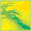
[cartography]
A raster in which cell values vary continuously to form a surface. In a continuous raster, the phenomena represented have no clear boundaries. Values exist on a scale relative to each other. It is assumed that the value assigned to each cell is what is found at the center of the cell. Rasters representing elevation, precipitation, chemical concentrations, suitability models, or distance from a road are examples of continuous rasters.