操作方法
操作方法:在 ArcGIS Online 中将 CAD 数据发布为托管要素服务
摘要
Computer-aided design (CAD) data such as AutoCAD's DWG file and Bentley MicroStation's DGN file can be integrated with ArcGIS Pro maps as feature datasets. However, these file formats are not supported in ArcGIS Online, so the data must be converted to a file geodatabase feature in ArcGIS Pro before publishing it as a hosted feature service to ArcGIS Online.
过程
- Convert the CAD dataset to a file geodatabase in ArcGIS Pro.
- On the ArcGIS Pro ribbon, click the Analysis tab > Tools.
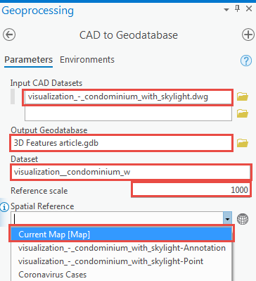
- In the Geoprocessing pane, search for the CAD To Geodatabase tool, and click it.
- For Input CAD Datasets, select the CAD dataset to be converted.
- For Output Geodatabase, specify the file geodatabase for the output dataset.
- For Dataset, specify a name for the dataset created.
- For Reference scale, specify a reference scale.
- For Spatial Reference, select Current Map [Map] from the drop-down menu.
- Click Run.
- Publish the file geodatabase to ArcGIS Online. Refer to ArcGIS Pro: Share a web feature layer using the default configuration for steps to do so.
文章 ID: 000024862
获得人工智能支持
使用 Esri Support AI Chatbot 快速解决您的问题。


相关信息
发现关于本主题的更多内容
Search for related information
Find training related to this topic
Explore ideas and give feedback
获取来自 ArcGIS 专家的帮助
立即开始聊天