操作方法
操作方法:在 ArcGIS Pro 的图像服务中裁剪并导出栅格图层,同时保留地图范围
摘要
图像服务是一种 web 服务,旨在存储、管理和分发大量的栅格和图像数据。 此服务通过基于 web 的界面提供影像访问,支持图像查看、分析及其他图像操作。 在 ArcGIS Pro 中,可以使用导出栅格窗格将图像服务的一部分导出为新的栅格图层,并将其裁剪为特定要素几何,同时保留要素图层的地图范围。 此方法通过关注较大数据集中的特定要素,同时保留原始地理覆盖范围,提升了栅格数据集的灵活性和效率。
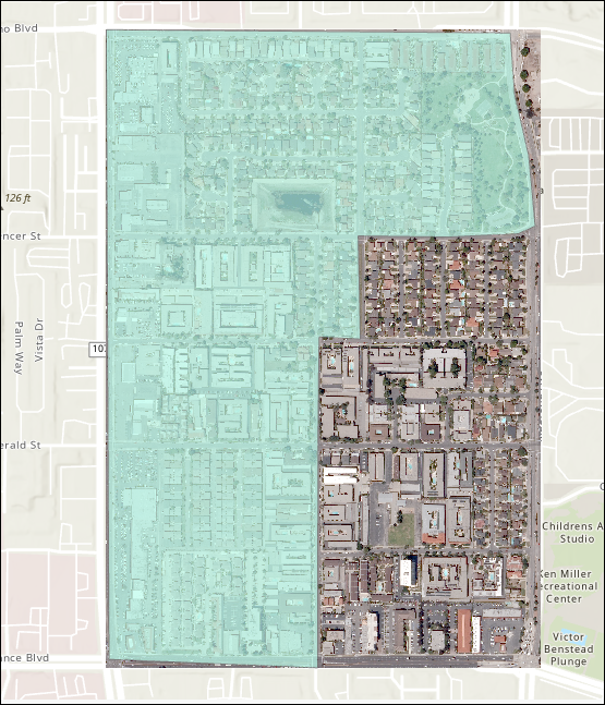
本文介绍了在 ArcGIS Pro 的图像服务中裁剪栅格,同时保留要素图层范围的工作流。 下图显示了用作裁剪几何的面要素图层,以裁剪图像服务的区域。
过程
- 在 ArcGIS Pro 中打开工程,然后登录到 ArcGIS Online 组织账户。 有关详细信息,请参阅 ArcGIS Pro:登录到您的组织。
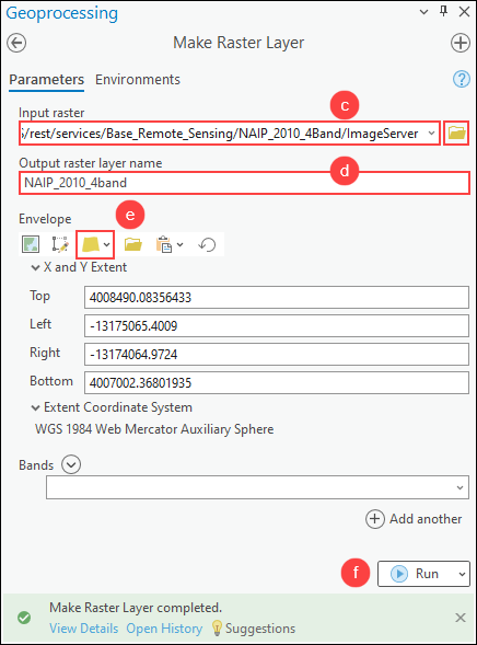
- 使用创建栅格图层工具,根据图像服务创建栅格图层。
- 在分析选项卡的地理处理组中,单击工具。
- 在地理处理窗格中,搜索并单击创建栅格图层(数据管理工具)。
- 在创建栅格图层窗格中,对于输入栅格,单击浏览
 ,在任何门户集合中搜索并选择图像服务。 有关说明,请参阅 ArcGIS Pro:搜索内容。
 - 指定输出栅格图层名称参数。
- 对于包络矩形,单击图层的范围
 ,然后选择具有预定义地图范围的要素图层。 在本示例中,将选择名为 LA_County 的面要素图层。
 - 单击运行。
Note:
The output of the Make Raster Layer tool is temporary and not retained after the session ends, unless the layer or map document is saved. To save the output layer, right-click the layer in the Contents pane and click Sharing > Save As Layer File, or use the Save To Layer File geoprocessing tool.
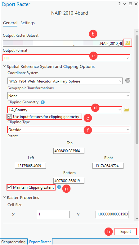
- 使用“导出栅格”窗格将栅格图层剪裁为面几何,同时保留裁剪范围。
- 在内容窗格中,右键单击步骤 2 中的输出栅格图层,然后单击数据 > 导出栅格。
- 在导出栅格窗格中,对于输出栅格数据集,单击浏览并指定输出栅格数据集的名称和位置。
- 对于输出格式,从下拉列表中选择输出栅格数据集的首选格式。 在本示例中,将选择 TIFF。
- 在空间参考系统和裁剪选项下,对于裁剪几何,从下拉列表中选择具有预定义地图范围的要素图层以用作输出范围。 在本示例中,将选择名为 LA_County 的面要素图层。
- 选中使用输入要素裁剪几何复选框。
- 对于裁剪类型,从下拉列表中选择首选裁剪类型。 在本示例中,将选择外部。
- 选中保留裁剪范围复选框。
- 单击导出。
Note:
Alternatively, clip the raster layer to the polygon geometry using the Clip function or the Extract by Mask tool. Refer to How To: Clip or extract an area of a raster image using polygon features in ArcGIS Pro for more information.
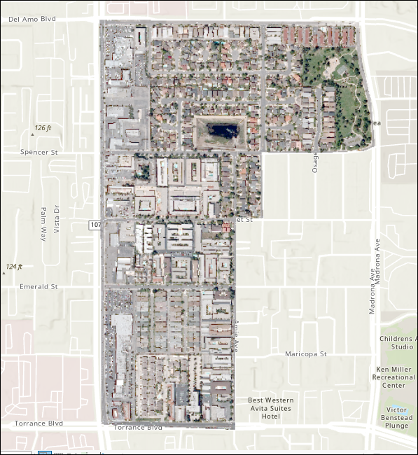
下图显示了在保留面要素图层范围的同时裁剪为面几何的栅格图层。
文章 ID: 000032806
获得人工智能支持
使用 Esri Support AI Chatbot 快速解决您的问题。


相关信息
发现关于本主题的更多内容
Search for related information
Find training related to this topic
Explore ideas and give feedback
获取来自 ArcGIS 专家的帮助
立即开始聊天