操作方法
操作方法:在 ArcGIS Pro 中计算跨表面的线要素的坡度
摘要
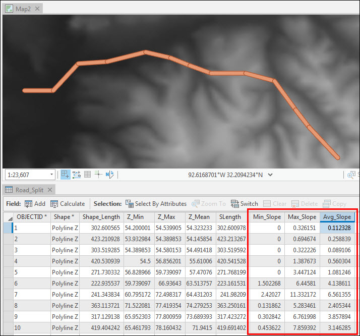
The properties of an elevation surface can be used to determine the slope of each segment along a line feature across the surface using the Add Surface Information tool. For example, calculating the slope of a hiking trail or a proposed road based on the spatial and elevation information derived from a raster layer. The slope at each cell of a grid is used to determine the slope of the line section crossing that cell. The tool attributes line features with the following slope information:
- Minimum slope is obtained from the segment whose value is closest to 0, or horizontal grade.
- Maximum slope is obtained from the segment with the largest calculated value.
- Average slope is obtained by weighing each slope by its 3D length, then determining the average. This results in longer segments having a greater influence on the resulting value over shorter segments.
过程
Note:
The Add Surface Information tool requires the 3D Analyst or Spatial Analyst license.
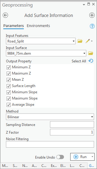
- In ArcGIS Pro, create a new project, and add the line feature class and elevation data. The elevation data can be in the form of an LAS dataset, mosaic, raster, terrain, or TIN surface.
- Optionally, split the line features at their vertices using the Split Line At Vertices tool. Splitting the lines allows the slope to be calculated for each line segment.
- Calculate the slope of the line features using the Add Surface Information tool.
- For Input Features, select the line feature class.
- For Input Surface, select the surface layer containing elevation data.
- For Output Property, check the check box for the spatial information to be written to the line feature's attribute table.
- If necessary, select a suitable interpolation method under Method.
- Click Run.
The image below shows the minimum, maximum, and average slope values of each line segment in percentage units (grade).
文章 ID: 000025428
获得人工智能支持
使用 Esri Support AI Chatbot 快速解决您的问题。


相关信息
发现关于本主题的更多内容
Search for related information
Find training related to this topic
Explore ideas and give feedback
获取来自 ArcGIS 专家的帮助
立即开始聊天