CÓMO
Crear líneas de curvas de nivel a partir de datos LIDAR
Descripción
LIDAR (detección y localización por luz) es una técnica de teledetección óptica que utiliza la luz de láser para obtener una muestra de la superficie de la Tierra y para producir mediciones exactas de x, y y z. Es posible crear líneas de curvas de nivel a partir de los datos LIDAR (.las), para proporcionar información sobre la elevación de la superficie de la Tierra. Cada entidad de línea de curvas de nivel se crea conectando puntos contiguos con valores de altura iguales a partir de los datos LIDAR.
Las instrucciones proporcionadas describen cómo crear líneas de curvas de nivel a partir de datos LIDAR.
Solución o solución alternativa
Cree un dataset LAS antes de crear líneas de curvas de nivel a partir de los datos LIDAR. Para obtener instrucciones sobre cómo crear un dataset LAS, consulte el siguiente documento de ayuda web, ArcMap: Crear un dataset LAS.
Note:
Spatial reference must be defined for each LAS file. ArcGIS reads and uses this spatial reference information. Defining the spatial reference at the LAS dataset level alone is not enough. LAS data might not be displayed due to different projections between the map and the LAS data, or the spatial reference for the LAS files is not defined properly.
Las curvas de nivel se pueden crear a partir de los datos LIDAR utilizando una de las opciones descritas.
Note:
The first option requires the 3D Analyst extension, and the second option requires either the 3D Analyst extension or the Spatial Analyst extension.
Crear líneas de curvas de nivel directamente a partir del dataset LAS
- Agregue el dataset LAS a ArcMap.
- Abra la herramienta Curvas de nivel de superficie. Vaya a Herramientas de 3D Analyst > Superficie triangulada > Curvas de nivel de superficie.
- Examine los datasets LAS como la Superficie de entrada.
- Asigne un nombre y una ubicación a la Clase de entidad de salida.
- Defina el parámetro Intervalo de curvas de nivel con el intervalo deseado entre las líneas de curvas de nivel.
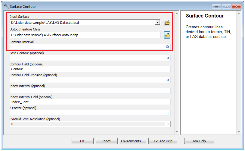
- Haga clic en Aceptar. Se crean en el mapa las líneas de curvas de nivel con el intervalo especificado.
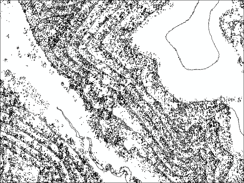
Las curvas de nivel creadas a partir de LIDAR de resolución completa tienden a ser irregulares, con muchas curvas y anillos cerrados aislados, debido al ruido de alta frecuencia. Para más información sobre el ruido de LIDAR y cómo conseguir curvas de nivel menos irregulares, consulte la siguiente documentación: Reducir al mínimo el ruido de LIDAR para la creación de curvas de nivel y el análisis de pendiente.
Crear líneas de curvas de nivel a partir de un ráster creado a partir del dataset LAS
- Agregue el dataset LAS a ArcMap.
- Abra la herramienta De dataset LAS a ráster. Vaya a Herramientas de conversión > A ráster > De dataset LAS a ráster.
- Examine el dataset LAS como Dataset LAS de entrada.
- Defina un nombre para Ráster de salida.
- Seleccione Colocación de bins para Tipo de interpolación.
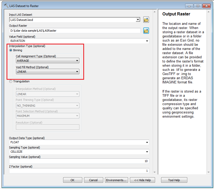
Note:
Binning interpolation determines the value of a pixel by examining the points that fall within the pixel to determine the final value. Triangulation interpolation is recommended for low-density Lidar data where it uses Delaunay triangulation to create a surface from a network of triangular facets defined by nodes and edges covering the surface before rasterizing it.
- Haga clic en Aceptar. Se muestra un ráster en el mapa.
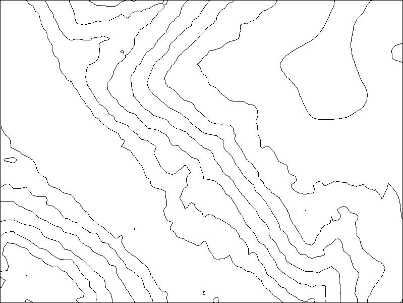
- Abra la herramienta Curvas de nivel. Vaya a Herramientas de 3D Analyst > Superficie ráster > Curva de nivel o, si la extensión 3D Analyst no está disponible, pero la extensión Spatial Analyst sí lo está, navegue hasta Spatial Analyst > Superficie > Curva de nivel.
- Examine el dataset ráster como Ráster de entrada.
- Defina un nombre y una ubicación para las entidades de polilínea de salida.
- Defina el parámetro Intervalo de curvas de nivel con el intervalo deseado entre las líneas de curvas de nivel.
- Haga clic en Aceptar. Las curvas de nivel con el intervalo especificado se muestran en el mapa.
Note:
Every Lidar point can have a classification assigned to it, defining the type of object that has reflected the laser pulse including bare earth or ground, the top of a forest canopy, or water. For more information of the Lidar data classification, refer to the following documentation: Lidar point classification. For steps to filter the Lidar data, refer to the following documentation, ArcMap: Filter tab.
Id. de artículo: 000015264
Obtenga soporte con IA
Resuelva su problema rápidamente con el chatbot de inteligencia artificial de soporte de Esri.


Información relacionada
Descubrir más sobre este tema
Search for related information
Find training related to this topic
Explore ideas and give feedback
Obtener ayuda de expertos en ArcGIS
Empieza a chatear ahora