HOW TO
Generate the coordinates of point features created in ArcGIS Online
Summary
In ArcGIS Online, point features can be used to visualize data on a web map. However, the coordinates of the point features are not generated or displayed in the feature layer's attribute table when point features are created. This article provides three methods to generate the coordinates of point features created in ArcGIS Online using the Export Data function, the Attribute Table widget in ArcGIS Web AppBuilder, or the Calculate Geometry Attributes tool in ArcGIS Pro.
Procedure
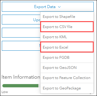
Export the point layer as an Excel or CSV file
Use this workflow to export all the point features in the hosted feature layer.
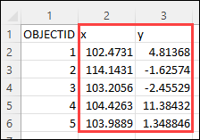
Note:
The output coordinates are displayed in decimal degrees .
In ArcGIS Online, when exporting a point layer to an Excel or CSV file, the latitude and longitude values for the points are exported to the output file. Refer to ArcGIS Online: Export data from hosted feature layers for more information on exporting the data of a point layer and obtaining the coordinates of the point features. Ensure the Export to CSV file option or the Export to Excel option is selected when exporting the data.
Coordinates of the point features are populated in the x column and y column in the exported Excel file.
Export the point features from ArcGIS Web AppBuilder
Use this workflow to export specific point features instead of all point features in the hosted feature layer. This workflow involves using the Attribute Table widget to export the point features to a CSV file that also includes the coordinates of the point features.
Note:
The output coordinates are displayed in esriMeters.
- In ArcGIS Web AppBuilder, create a web app and add the web map containing the point feature layer to the app. Optionally, create a new web map with the point feature layer to be used in the web app. Refer to ArcGIS Web AppBuilder: Select a map for more information.
- Configure the Attribute Table widget. Refer to ArcGIS Web AppBuilder: Configure the Attribute Table widget for instructions. Ensure the Allow exporting to CSV option is checked.
- Click Save to save the web app.
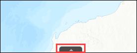
- In this web app, click the arrow button at the bottom of the web app to view the attribute table. Alternatively, click the Attribute Table widget in the web app to view the attribute table.
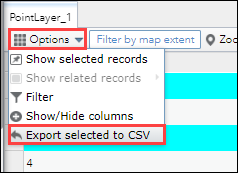
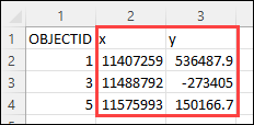
- On the attribute table, select the point features to be exported. Press the Ctrl key on the keyboard to select multiple point features. In this example, point features with the OBJECTID of 1, 3, and 5 are selected.
- Click Options, and click Export selected to CSV.
- In the Export to CSV window, click OK.
The coordinates of the selected point features are populated in the exported CSV file.
Calculate the coordinates in ArcGIS Pro
This workflow provides the option to customize the geometry attributes and coordinate format of the output. This workflow involves opening the point feature layer in ArcGIS Pro and using the Calculate Geometry Attributes tool to calculate the XY coordinates.
- Open the point feature layer in ArcGIS Pro.
- In ArcGIS Online, navigate to Content > My Content, and open the point feature layer.
- On the item details page, on the Overview tab, click Open in ArcGIS Desktop > Open in ArcGIS Pro. A .pitemx file is downloaded.
- Double-click the downloaded file to open the point feature layer in ArcGIS Pro.
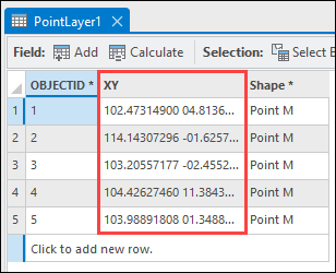
- In ArcGIS Pro, calculate the XY coordinates of the point features using the Calculate Geometry Attributes tool. Refer to How To: Calculate the XY coordinates of point features in ArcGIS Pro for instructions.
The XY coordinates of the point feature are populated in the attribute table.
Article ID: 000028424
- ArcGIS Web AppBuilder
- ArcGIS Online
Get support with AI
Resolve your issue quickly with the Esri Support AI Chatbot.


Related Information
Discover more on this topic
Search for related information
Find training related to this topic
Explore ideas and give feedback
Get help from ArcGIS experts
Start chatting now