HOW TO
Append geocoded records to an existing feature layer in ArcGIS Online
Summary
Geocoding in ArcGIS Online converts an address or a place to an x,y coordinate, and appends the result to an existing record in a database. In some instances, it is necessary to append new geocoded records to an existing feature layer for mapping or spatial analysis.
This articles describes steps to append geocoded records to an existing feature layer in ArcGIS Online.
Procedure
Note:
Geocoding services in ArcGIS Online consumes credits. Refer to ArcGIS Online: Understand credits for more information.
- Geocode the records in ArcGIS Online.
- On the ArcGIS Online Content page, add the file containing the geocoding information. Refer to ArcGIS Online: Add files from your computer for steps to do this.
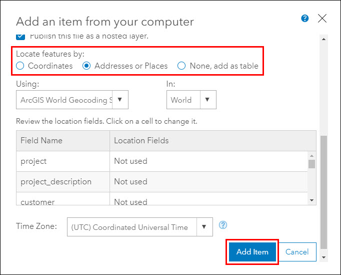
- For Locate features by, select Addresses or Places.
- Configure other parameters as necessary, and click Add Item. ArcGIS Online creates a new feature layer with the geocoded records.
- Export the new feature layer as a file geodatabase, and download the exported file geodatabase.
- Open the item details page of the new feature layer.
- Click Export Data > Export to FGDB.
- In the Export to File Geodatabase window, fill in the parameters, and click Export. A file geodatabase item is created in the ArcGIS Online content page.
- Open the item details page of the exported file geodatabase, and click the Download button to download it.
- Append the downloaded file geodatabase to the existing feature layer.
- Open the item details page of the existing layer to append the new geocoded records.
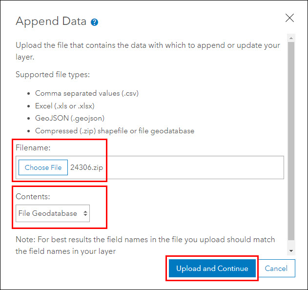
- Click the Update Data button, and click Append Data to Layer.
- In the Append Data window, for Filename, select the downloaded file geodatabase.
- For Contents, select File Geodatabase, and click Upload and Continue.
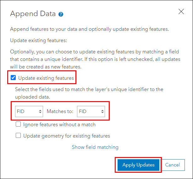
- Ensure the Update existing features check box is checked, and select the fields used to match the layer's unique identifier to the uploaded data.
- Click Apply Updates to append the data.
The geocoded records are successfully appended to the existing feature layer in ArcGIS Online. To view the appended data, click the Data tab on the layer's item details page to open the attribute table.
Article ID: 000024306
- ArcGIS Online
Get support with AI
Resolve your issue quickly with the Esri Support AI Chatbot.


Related Information
Discover more on this topic
Search for related information
Find training related to this topic
Explore ideas and give feedback
Get help from ArcGIS experts
Start chatting now