HOW TO
Manage automatic ground control point detection in Site Scan Manager for ArcGIS
Summary
Site Scan Manager for ArcGIS can detect ground control points (GCPs) within the images collected from the drone. This article reviews what objects can be considered GCPs, how detection occurs, and modifications that can be made to the detected GCPs within the application.
Objects used as GCPs, such as spray-painted marks and movable marker objects, are used to assist in georeferencing a drone flight. These objects can be automatically detected by Site Scan Manager once the flight is uploaded. This helps in locating the GCPs within the collected images, expediting imagery processing workflows.
Procedure
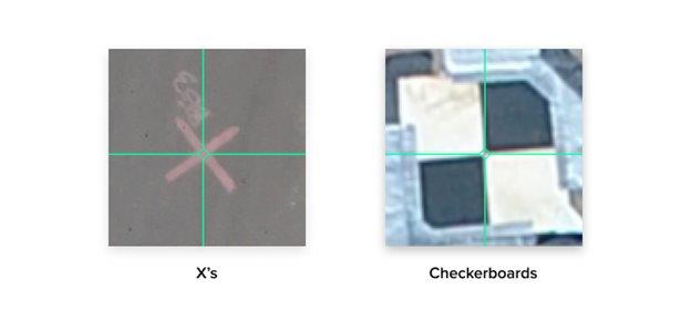
Site Scan for ArcGIS uses computer vision to detect certain types of ground control points in aerial photos. The model is trained to detect an orange or white spray-painted X, or a black and white checkerboard pattern as a GCP, as shown in the images below. Overall detection becomes more accurate as more photos are processed within the model.
Workflow
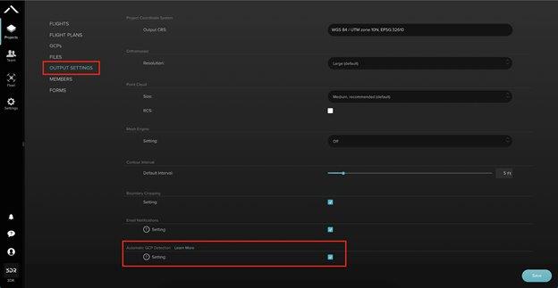
It is necessary to turn on Auto GCP Detection for the project in which it is used.
- Navigate to the Projects tab on the main sidebar.
- Select a project in which to enable the feature.
- Under Output Settings, scroll to the bottom of the page, check the Automatic GCP Detection button, and click Save.
- Process the mission.
Note: Do not tag any GCPs manually otherwise Auto-GCP detection will not be performed.
When GCPs have been auto-detected in a flight, and there is a GCP set uploaded to the project, there will be an additional button in the Ground Control Points layer drop-down called Review Detected GCPs.
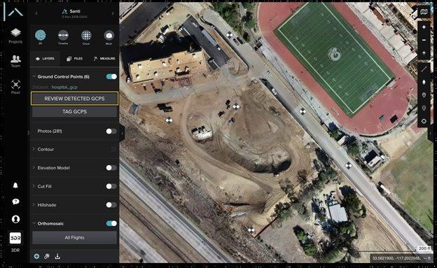
After selecting to review GCPs, the following can be observed:
- All of the flight's image thumbnails with GCPs auto-detected or estimated
- The total amount of GCPs detected
- The name of each GCP set, and the number of photos that have been detected or estimated GCPs
- The date of upload for the project's GCP set
- The number of GCPs that have or have not been detected in multiple pictures
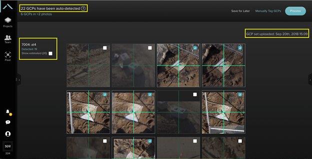
Types of detection
There are two types of detection in the Site Scan for ArcGIS computer vision GCP workflow: detected and estimated.
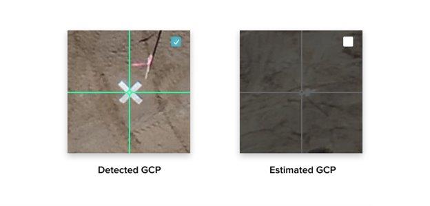
An image with a detected GCP is automatically selected for processing. An image with an estimated GCP is automatically deselected and will not be used in processing, but can be selected and adjusted if a GCP exists. 'Estimated' means a GCP was not detected, but could exist in the image.
Adjust and Process GCPs
It may be necessary to re-center the detected GCPs in the images. To adjust this, move the image in the thumbnail to align the center of the GCP with the green or white cross-hairs. For a closer look, select the top-left expand icon for the image to expand it.
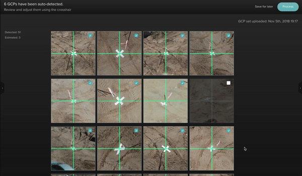
To finish, click the Process button on the top-right of the window to process the flight with these tagged GCPs, or Save for Later to review the GCPs at a different time. It is also possible to select the standard manual GCP tagging flow at any point by clicking the Save for later button next to the Process button.
Article ID: 000023062
- Site Scan Manager for ArcGIS
Get support with AI
Resolve your issue quickly with the Esri Support AI Chatbot.


Related Information
Discover more on this topic
Search for related information
Find training related to this topic
Explore ideas and give feedback
Get help from ArcGIS experts
Start chatting now