PROBLEM
Unable to run LAS Dataset To Raster in ArcGIS Pro
Description
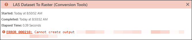
The conversion of lidar datasets to raster formats in ArcGIS Pro simplifies the visualization of large datasets and enables the straightforward analysis and interpretation of spatial data. In some instances, when running the LAS Dataset To Raster tool, the tool fails and returns the following error message:
Error:
000210: Cannot create output <value>.
Cause
- The input LAS dataset is corrupted.
- The output raster dataset is stored in a network drive.
- The input LAS dataset is defined as a geographic coordinate system. The LAS Dataset To Raster tool requires a projected coordinate system to perform accurate rasterization with consistent linear units.
Solution or Workaround
Depending on the cause, the workarounds described below are applicable.
Create a new LAS dataset
In ArcGIS Pro, create a new LAS dataset using the Create LAS Dataset tool. Refer to ArcGIS Pro: Create a LAS dataset for more information.
Save the output LAS dataset on the local machine
When using the LAS Dataset To Raster tool, save the output LAS dataset to a local machine to avoid potential access and network issues.
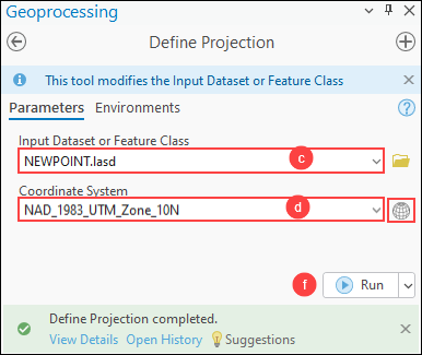
Define a projection for the LAS dataset as a projected coordinate system
- Open the project in ArcGIS Pro.
- Project the LAS dataset to a projected coordinate system using the Define Projection tool.
- On the Analysis tab, in the Geoprocessing group, click Tools.
- In the Geoprocessing pane, search for and click Define Projection (Data Management Tools).
- In the Define Projection pane, for Input Dataset or Feature Class, select the LAS dataset from the drop-down list.
- For Coordinate System, click Select coordinate system
 to open the Coordinate System window.
 - In the Coordinate System window, expand Projected Coordinate System to specify the coordinate system. Ensure the coordinate system for the output feature class matches the coordinate system of the lidar dataset to accurately position features relative to each other and the earth’s surface. In this example, NAD 1983 UTM Zone 10N is selected. Click OK.
- Click Run.
Article ID: 000034193
- ArcGIS Pro 3 3
- ArcGIS Pro 3 2
- ArcGIS Pro 3 4
Get support with AI
Resolve your issue quickly with the Esri Support AI Chatbot.


Related Information
Discover more on this topic
Search for related information
Find training related to this topic
Explore ideas and give feedback
Get help from ArcGIS experts
Start chatting now