PROBLEM
Raster cell values are overridden when combined with NoData values in ArcGIS Pro
Description
The Combine tool in ArcGIS Pro is used to merge raster layers by assigning a unique identifier to each combination of cell values from the input rasters. When using this tool, NoData values override existing cell values that result in an output raster filled with NoData and excludes critical areas from analysis, leading to inconsistencies in the final output.
Cause
The Combine tool considers cells with NoData values to be missing or incomplete. When the input raster contains NoData values, the tool is unable to assign a combined code for the area, even if the other layers contain valid data.
Solution or Workaround
Convert or exclude these NoData values before running the tool to ensure accurate results.
Exclude NoData values using the 'Extract by Mask' tool
Note:
This tool requires a Spatial Analyst license.
- Open the ArcGIS Pro project.
- Create a polygon feature for the region wherein the value is valid. Refer to ArcGIS Pro: Create a polygon feature for instructions.
- Exclude the raster NoData values using the Extract by Mask tool.
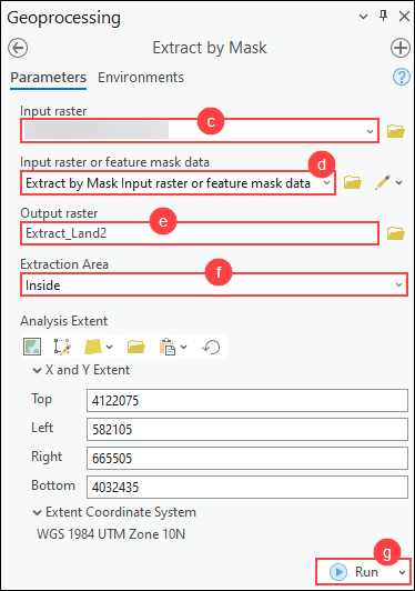
- On the Analysis ribbon tab, in the Geoprocessing group, click Tools.
- In the Geoprocessing pane, search for and click Extract by Mask (Spatial Analyst Tools).
- For Input raster, select the raster dataset layer from the drop-down list.
- For Input raster or feature mask data, select the output polygon feature layer created in Step 2 from the drop-down list.
- For Output raster, specify a name and location.
- For Extraction Area, select Inside from the drop-down list.
- Click Run.
Reclassify NoData values to a specific class using the Reclassify tool
Note:
This tool requires a Spatial Analyst or 3D Analyst license.
- Open the ArcGIS Pro project.
- Reclassify NoData values to valid values using the Reclassify tool.
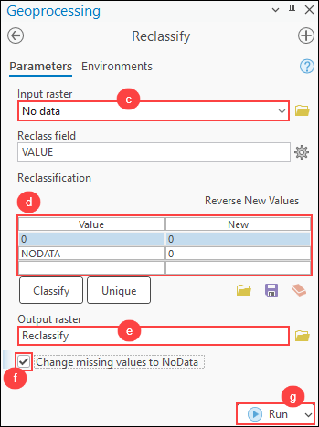
- On the Analysis ribbon tab, in the Geoprocessing group, click Tools.
- In the Geoprocessing pane, search for and click Reclassify (Spatial Analyst Tools).
- In the Reclassify pane, for Input raster, select the raster dataset layer from the drop-down list.
- For Reclassification, specify a new value to be assigned to the NoData values in the output raster. In this example, the value is 0.
- For Output raster, specify a name and its location.
- Check the Change missing values to NoData check box.
- Click Run.
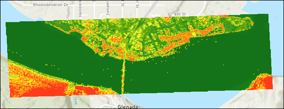
The map shows the combined output raster after excluding or reclassifying the NoData values in the raster datasets.
Article ID: 000034184
- ArcGIS Pro 3 3
- ArcGIS Pro 3 2
- ArcGIS Pro 3 4
Get support with AI
Resolve your issue quickly with the Esri Support AI Chatbot.


Related Information
Discover more on this topic
Search for related information
Find training related to this topic
Explore ideas and give feedback
Get help from ArcGIS experts
Start chatting now