PROBLEM
Polygon outlines not displayed when the hatch fill symbol is used in ArcGIS Online and the Enterprise portal
Description
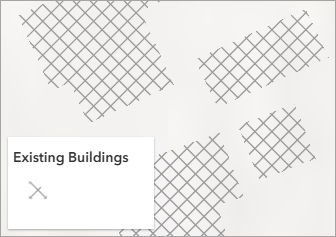
In ArcGIS Online and the ArcGIS Enterprise portal, when polygon features are configured with certain hatch fill symbols, the outlines are not displayed, causing the polygon features to appear incomplete, reducing overall map readability.
The web map shows the polygon features with missing outlines after the hatch fill symbol is used in Map Viewer.
Cause
The hatch fill symbols are primarily designed to emphasize interior patterns rather than the boundaries of a feature. With certain hatch fill symbols, the feature outlines appear hidden due to rendering constraints or conflicts between the stroke and the fill layer.
Solution or Workaround
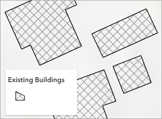
Add a stroke layer to the existing hatch fill symbology in ArcGIS Pro
- Open the web map in ArcGIS Pro. Refer to ArcGIS Pro: Add a web map or web scene for instructions.
- Add a stroke layer to the existing hatch fill symbology. Refer to ArcGIS Pro: Add a symbol layer for instructions. In Step 3, select Stroke layer.
- Save the web map. Refer to Steps 3 through 11 in ArcGIS Pro: Save a web map in a portal for instructions.
The web map below shows the updated symbology of the polygon features in Map Viewer.
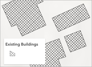
Configure the hatch fill symbology with outlines in ArcGIS Pro
Note:
This workaround is recommended when an alternative hatch fill symbol is applicable.
- Open the web map in ArcGIS Pro. Refer to ArcGIS Pro: Add a web map or web scene for instructions.
- Configure the polygon feature symbology with hatch fill symbology that has outlines.
- On the Feature Layer tab, in the Drawing group, click Symbology.
- In the Symbology pane, click the current symbol and select a hatch fill symbol with outlines. In this example, 10% Crosshatch is selected.
- Save the web map. Refer to Steps 3 through 11 in ArcGIS Pro: Save a web map in a portal for instructions.
The web map below shows the updated symbology of the polygon features in Map Viewer.
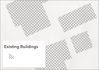
Use a hatch fill symbol with outlines in Map Viewer
Note:
This workaround is recommended when an alternative hatch fill symbol is applicable.
- Open the web map with the polygon features in Map Viewer.
- Change the hatch fill symbol style.
- On the Contents (dark) toolbar, click Layers
 .
. - In the Layers pane, select the polygon feature layer.
- On the Settings (light) toolbar, click Styles

- In the Styles pane, under Pick a style, click Style options.
- In the Style options pane, click the symbol under Symbol style.
- In the Symbol style pane, click the symbol under Current symbol.
- Select a symbol with outlines from the Hatch Fill category. In this example, A Crosshatch is selected.
- In the Symbol style pane, click Done.
- In the Styles pane, click Done.
- In the Styles pane, click Done once more to apply the symbology to the polygon features.
- On the Contents (dark) toolbar, click Layers
The web map below shows the polygon features symbolized with a different hatch fill symbol, making the outlines visible in Map Viewer.
Article ID: 000035060
- ArcGIS Online
- Portal for ArcGIS
- ArcGIS Enterprise
Get support with AI
Resolve your issue quickly with the Esri Support AI Chatbot.


Related Information
Discover more on this topic
Search for related information
Find training related to this topic
Explore ideas and give feedback
Get help from ArcGIS experts
Start chatting now