PROBLEM
Data relationship from a hosted feature layer not displayed in ArcGIS Online or Enterprise Map Viewer
Description
In ArcGIS Enterprise or ArcGIS Online Map Viewer, when accessing the data relationship from the hosted feature layer published from a file geodatabase, the data are not displayed or accessible. The data relationship from the hosted feature layer fails to populate and display in the pop-up and result in missing information, reducing the ability to analyze spatial relationships between spatial features and attributes or accurately validate data.
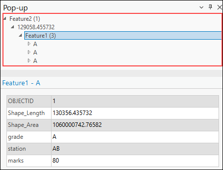
The image below shows the data relationship between feature layers in ArcGIS Pro, which is not visible in Map Viewer.
Cause
- The feature layer is not permanently joined or related. In ArcGIS Pro, the Add Join and Add Relate tools create only temporary data relationships within the table.
- Data relationships are created using unsupported many-to-many cardinality.
- The relationship class is deleted from the file geodatabase before publishing.
Solution or Workaround
Depending on the cause, the workarounds provided are applicable.
Create a relationship class from the related dataset in ArcGIS Pro
- Open the project in ArcGIS Pro.
- Create a relationship class from the related dataset using the Create Relationship Class tool.
- Publish the related feature layer as a web feature layer to the ArcGIS Enterprise portal or ArcGIS Online. Refer to ArcGIS Pro: Share a web feature layer using the default configuration for instructions.
Join the attribute table using the Join Field tool and export as a new feature layer
- Open the project in ArcGIS Pro.
- Join the contents of the attribute table to another table based on a common attribute field using the Join Field tool.
- Export the joined feature layer as a new feature layer using the Copy Features, Copy Rows, Export Features, or Export Table tools. Use the joined feature layer as an input to the desired tools.
- Publish the related feature layer as a web feature layer to the ArcGIS Enterprise portal or ArcGIS Online. Refer to ArcGIS Pro: Share a web feature layer using the default configuration for instructions.
Use supported relational cardinality in Map Viewer
ArcGIS Enterprise and ArcGIS Online Map Viewer support one-to-one and one-to-many relationships between layers and tables, as defined through relationship classes in a file geodatabase. When displaying related data in pop-ups or attribute tables, both the origin and destination layers or tables must be added to the map. If only one side of the relationship is included, Map Viewer cannot access or display the related records, even if the relationship exists in the hosted feature layer. Refer to Portal for ArcGIS: Show related records or ArcGIS Online: Show related records for more information.
Ensure the file geodatabase contains all relationship classes before publishing
When publishing a feature layer to the ArcGIS Enterprise portal or ArcGIS Online using a file geodatabase, a relationship class must be included in the zipped geodatabase. This inclusion of relationship classes ensures relationships between feature classes and related tables are preserved in the hosted feature layer. Refer to Portal for ArcGIS: Publish the contents of a file geodatabase or ArcGIS Online: Publish the contents of a file geodatabase for more information.
Use the Join Features tool in Map Viewer
Alternatively, if the hosted feature layer is not properly configured or does not have a defined data relationship, use the Join Features tool in Map Viewer to generate it. This tool joins attributes from one layer or table to another based on shared spatial or attribute values. Refer to Portal for ArcGIS: Join Features (Map Viewer) or ArcGIS Online: Join Features for instructions.
Article ID: 000035878
- ArcGIS Pro
- ArcGIS Online
- Portal for ArcGIS
- ArcGIS Enterprise
Get support with AI
Resolve your issue quickly with the Esri Support AI Chatbot.


Related Information
Discover more on this topic
Search for related information
Find training related to this topic
Explore ideas and give feedback
Get help from ArcGIS experts
Start chatting now