HOW TO
Symbolize outermost borders of adjacent polygons within a feature layer in ArcGIS Pro
Summary
In ArcGIS Pro, polygon borders serve not only for cartographic and aesthetic design but also to convey information, including boundaries and topological relationships. However, the neighboring polygon edges may be adjacent or overlaying, which reduces the map readability. Therefore, symbolizing only the enclosing border of multiple adjacent polygons is a great alternative to simplify the map and emphasize the outermost border. This article provides workflows to symbolize the outermost border of adjacent polygons within the same feature layer in ArcGIS Pro.
Procedure
Dissolve and symbolize the adjacent polygons as a single polygon feature
- Add the polygon layer to an ArcGIS Pro project.
- Dissolve the adjacent polygons using the Pairwise Dissolve or the Dissolve Boundaries tool.
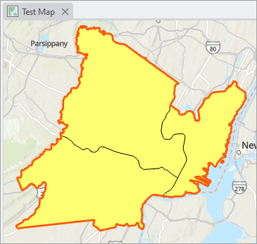
- Configure the symbology of the output polygon layer as preferred. In this example, the polygon fill is set to No color, and the border is symbolized with a wider line and a different color to enhance the border visibility.
The map below shows the output polygon layer with the symbolized border in ArcGIS Pro.
Hide the polygon edges using a mask layer
- Add the polygon layer to an ArcGIS Pro project.
- Duplicate the polygon layer.
- Copy the existing polygon layer. Refer to Steps 1 and 2 in ArcGIS Pro: Copy all properties for instructions.
- In the Contents pane, right-click the map and click Paste.
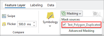
- Configure the duplicated polygon layer as a mask layer for the existing polygon layer. Refer to ArcGIS Pro: Use layer masking for instructions. In Step 4, check the duplicated polygon layer created in Step 2.
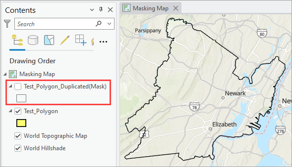
The map below shows the inner polygon edges masked by the duplicated polygon layer in ArcGIS Pro.
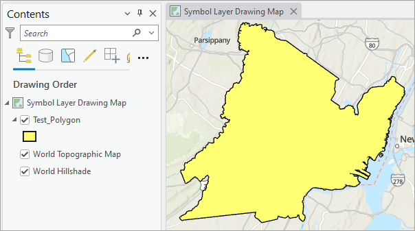
Reorder the symbol layer drawing of the polygon layer
Note:
This workflow is useful when creating or modifying the original feature is not desirable.
- Add the polygon layer to an ArcGIS Pro project.
- Enable symbol layer drawing and reorder the individual symbol layer of the polygon feature layer. Refer to Steps 1 through 4 in ArcGIS Pro: Reorder individual symbol layers with the advanced mode for instructions. In Step 4, for Drawing Order, reorder the polygon fill group as the topmost order and followed by the polygon edge group.
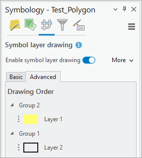
The map below shows the polygon layer configured with the polygon fill as the topmost drawing order, hiding the inner polygon edges in ArcGIS Pro.
Article ID: 000034651
- ArcGIS Pro 3 3
- ArcGIS Pro 3 2
- ArcGIS Pro 3 4
Get support with AI
Resolve your issue quickly with the Esri Support AI Chatbot.


Related Information
Discover more on this topic
Search for related information
Find training related to this topic
Explore ideas and give feedback
Get help from ArcGIS experts
Start chatting now