HOW TO
Disable feature selection for specific layers in ArcGIS Experience Builder
Summary
In ArcGIS Experience Builder, features on a map can be selected and interacted with by clicking the features or by using the Select tool. In instances when a map contains visible layers overlapping one another, disabling feature selection for specific layers can improve the user experience. However, there is no built-in function in ArcGIS Experience Builder to only limit feature selection for specific layers. This article provides two workarounds to disable feature selection for specific layers on a map in ArcGIS Experience Builder.
Procedure
Depending on the feature selection method, follow one of the workarounds below to disable feature selection for specific layers. In this article, the polygon hosted feature layer is used to demonstrate the workflows.
Remove the hosted feature layer pop-ups
Follow this workaround if the Select tool is not enabled in the Map widget. Disable the feature selection of a layer by removing the pop-ups in Map Viewer.
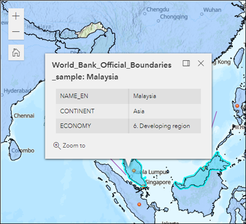
The polygon representing Malaysia is highlighted and the pop-up is displayed.
- Remove the hosted feature layer pop-ups.
- To remove the pop-ups in Map Viewer, refer to ArcGIS Online: Enable and remove pop-ups.
- To remove the pop-ups in Map Viewer Classic, refer to ArcGIS Online: Enable and remove pop-ups.
- Save the changes made.
- Refresh the ArcGIS Experience Builder experience.
The polygon features cannot be clicked and highlighted. Only the point and line features can be clicked and highlighted.
Publish the hosted feature layer as a hosted tile layer
If the Select tool is enabled in the Map widget, follow this workaround to disable the Select tool from selecting features on the hosted feature layer.
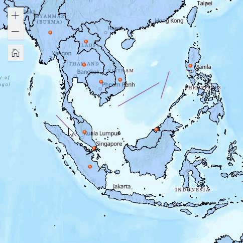
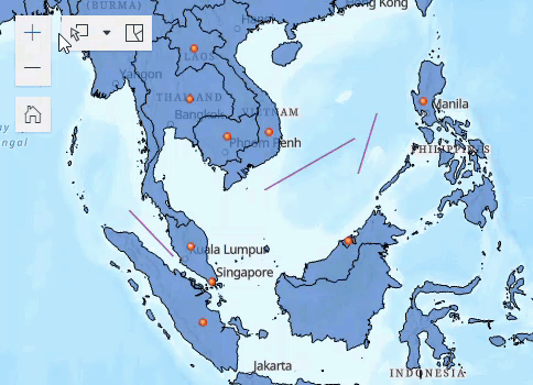
The point, line, and polygon features are selected using the Select tool.
- In ArcGIS Online, publish the hosted feature layer as a hosted tile layer. Refer to ArcGIS Online: Publish hosted tiles from hosted features for more information. In this example, the polygon hosted feature layer is published as a hosted tile layer.
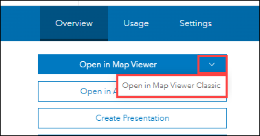
- On the item details page of the web map added to ArcGIS Experience Builder, click the down arrow next to Open in Map Viewer, and click Open in Map Viewer Classic.
- Add the hosted tile layer to the web map. Refer to ArcGIS Online: Search for layers for instructions.
- In the Contents pane, remove or uncheck the box to hide the original hosted feature layer. In this example, the original polygon hosted feature layer, World Bank Official Boundaries is unchecked.
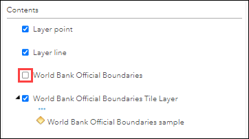
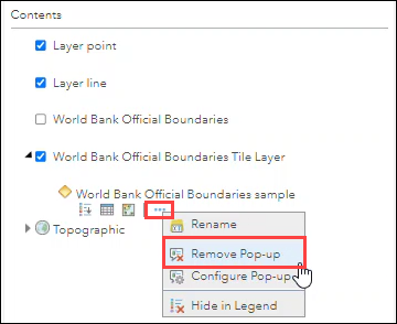
- If necessary, expand the hosted tile layer, and remove the pop-ups. Pop-ups are automatically enabled for hosted tile layers. Refer to ArcGIS Online: Enable and remove pop-ups for instructions to disable pop-ups for the hosted tile layer only.
Note:
The Disable pop-up option of the Map widget in ArcGIS Experience Builder applies to all the layers added to the map.
- Click Save to save the web map.
- Refresh the ArcGIS Experience Builder experience.
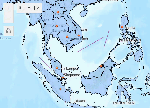
Feature selection using the Select tool is disabled for the polygon hosted tile layer. Point features and line features can still be selected.
Article ID: 000027677
- ArcGIS Online
- ArcGIS Experience Builder
Get support with AI
Resolve your issue quickly with the Esri Support AI Chatbot.


Related Information
Discover more on this topic
Search for related information
Find training related to this topic
Explore ideas and give feedback
Get help from ArcGIS experts
Start chatting now