HOW TO
Create road polygons from centerlines in ArcGIS Pro
Summary
On most maps, roads are represented as centerlines showing only the path and lacking physical details such as width or sidewalk extent. To create more realistic road polygons, the centerlines can be buffered to an approximate reserve width, and overlapping neighboring features can be clipped. This method is useful when centerline data is the sole source available for analyzing reserve extents such as shoulders and sidewalks, particularly near parcel boundaries in an urban planning context.
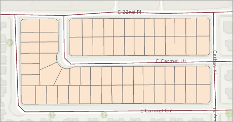
This article provides the workflow for creating road polygons from centerlines in ArcGIS Pro. The workflow is illustrated using road centerline features alongside parcel features, as shown in the image below.
Procedure
- Open the ArcGIS Pro project.
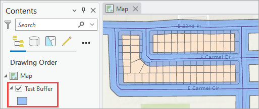
- Create polygons from the centerlines using the Pairwise Buffer tool.
- On the ribbon, click the Analysis tab.
- On the Analysis tab, in the Geoprocessing group, click Tools.
- In the Geoprocessing pane, search for and select the Pairwise Buffer (Analysis Tools) tool.
- In the Pairwise Buffer pane, for Input Features, click the drop-down arrow and select the road centerline feature layer.
- For Output Feature Class, specify a name. Click Browse and specify a location for the output feature class.
- For Distance [value or field], specify the value and unit as desired. Refer to ArcGIS Pro: Parameters for more information.
- Click Run.
The polygon feature layer is added to the Contents pane and displayed on the map view.
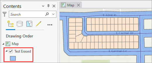
- Remove the overlapping areas of the polygons and the parcels using the Pairwise Erase tool to create road polygons.
- In the Pairwise Buffer pane, click Back
 .
. - In the Geoprocessing pane, search for and select the Pairwise Erase (Analysis Tools) tool.
- In the Pairwise Erase pane, for Input Features, click the drop-down arrow and select the output polygon feature layer from Step 2.
- For Erase Features, click the drop-down arrow and select the parcel feature layer.
- For Output Feature Class, specify a name. Click Browse and specify a location for the output feature class.
- Click Run.
- In the Pairwise Buffer pane, click Back
Note:
Optionally, in the Contents pane, uncheck the polygon feature layer to turn the visibility off to display only the Pairwise Erase output feature layer.
The road polygon feature layer with overlaps removed is added to the Contents pane and displayed on the map view.
Article ID: 000036180
- ArcGIS Pro
Get support with AI
Resolve your issue quickly with the Esri Support AI Chatbot.


Related Information
Discover more on this topic
Search for related information
Find training related to this topic
Explore ideas and give feedback
Get help from ArcGIS experts
Start chatting now