HOW TO
Create a boundary for multiple contour feature layers in ArcGIS Pro
Summary
Contours represent elevation or depth variations of a surface and are essential for visualizing geological structures and terrain features. Creating a boundary for contours improves mapping accuracy and geological analysis by limiting data to relevant regions, ensuring only the area of interest is analyzed. This article describes the workflow to create the boundary for multiple contour feature layers in ArcGIS Pro.
Procedure
Note:
The workflow below requires the ArcGIS Pro Standard or Advanced license.
- Open the ArcGIS Pro project.
Note:
For instructions to find and use a geoprocessing tool, refer to ArcGIS Pro: Find a geoprocessing tool.
- Merge the contour feature layers using the Merge tool.
- Convert the merged contour feature layer to a raster dataset using the Feature to Raster tool.
- Create an empty mosaic dataset in the file geodatabase. Refer to ArcGIS Pro: Create a mosaic dataset for instructions.
- Add the raster dataset to the newly created mosaic dataset using the Add Rasters To Mosaic Dataset tool.
- In the Add Rasters To Mosaic Dataset pane, for Mosaic Dataset, select the mosaic dataset created from Step 4.
- For Raster Type, select Raster Dataset.
- For Input Data, select Dataset from the drop-down list. Click the Browse icon, navigate to the location, and select the raster dataset created in Step 3.
- Click Run.
- Compute the extent of the raster in the mosaic dataset using the Build Footprints tool.
- In the Catalog pane, right-click the mosaic dataset and click Modify > Build Footprints.
- In the Build Footprints pane, for Mosaic Dataset, select the mosaic dataset from Step 4.
- Click Run.
- Use the Copy Features tool to export and convert the mosaic boundary from Step 6 into a new feature layer.
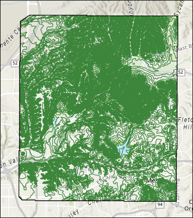
The map below shows the boundary of the contour feature layers.
Article ID: 000035013
- ArcGIS Pro 3 3
- ArcGIS Pro 3 2
- ArcGIS Pro 3 4
Get support with AI
Resolve your issue quickly with the Esri Support AI Chatbot.


Related Information
Discover more on this topic
Search for related information
Find training related to this topic
Explore ideas and give feedback
Get help from ArcGIS experts
Start chatting now