HOW TO
Clip and export a raster layer from an image service while preserving the map extent in ArcGIS Pro
Summary
An image service is a web service designed to store, manage, and distribute a large collection of raster and image data. This service provides access to imagery through a web-based interface, which allows image viewing, analysis, and other image operations. In ArcGIS Pro, a portion of an image service can be exported as a new raster layer and clipped to a specific feature geometry while preserving the map extent of the feature layer using the Export Raster pane. This method improves the flexibility and efficiency of raster datasets by focusing on specific features within the larger dataset while maintaining the original geographic coverage.
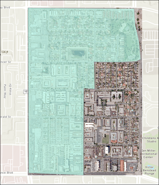
This article describes the workflow to clip a raster from an image service while preserving the feature layer extent in ArcGIS Pro. The image below shows a polygon feature layer used as the clipping geometry to clip the area of the image service.
Procedure
- Open the project in ArcGIS Pro and log in to an ArcGIS Online organizational account. Refer to ArcGIS Pro: Sign in to your organization for more information.
- Create a raster layer from the image service using the Make Raster Layer tool.
- On the Analysis tab, in the Geoprocessing group, click Tools.
- In the Geoprocessing pane, search for and click Make Raster Layer (Data Management Tools).
- In the Make Raster Layer pane, for Input raster, click Browse
 search for and select the image service from any portal collection. Refer to ArcGIS Pro: Search for content for instructions.
 - Specify the Output raster layer name parameter.
- For Envelope, click Extent of a Layer
 and select the feature layer with a predefined map extent. In this example, the polygon feature layer named LA_County is selected.
 - Click Run.
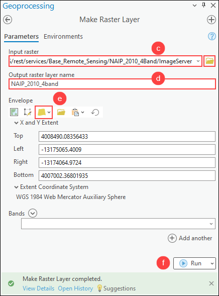
Note:
The output of the Make Raster Layer tool is temporary and not retained after the session ends, unless the layer or map document is saved. To save the output layer, right-click the layer in the Contents pane and click Sharing > Save As Layer File, or use the Save To Layer File geoprocessing tool.
- Clip the raster layer to the polygon geometry while preserving the clipping extent using the Export Raster pane.
- In the Contents pane, right-click the output raster layer from Step 2 and click Data > Export Raster.
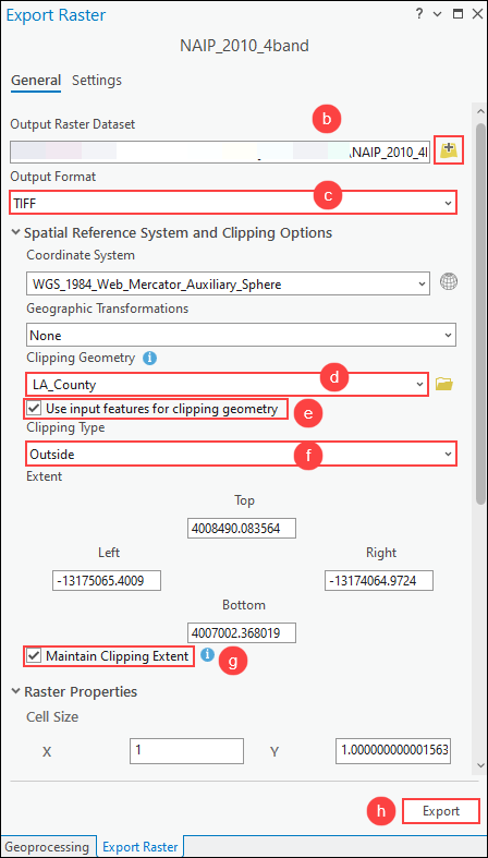
- In the Export Raster pane, for Output Raster Dataset, click Browse and specify a name and location for the output raster dataset.
- For Output Format, select the preferred format for the output raster dataset from the drop-down list. In this example, TIFF is selected.
- Under Spatial Reference System and Clipping Options, for Clipping Geometry, select the feature layer with a predefined map extent from the drop-down list to be used for the output extent. In this example, the polygon feature layer named LA_County is selected.
- Check the Use input features for clipping geometry check box.
- For Clipping Type, select the preferred clipping type from the drop-down list. In this example, Outside is selected.
- Check the Maintain Clipping Extent check box.
- Click Export.
Note:
Alternatively, clip the raster layer to the polygon geometry using the Clip function or the Extract by Mask tool. Refer to How To: Clip or extract an area of a raster image using polygon features in ArcGIS Pro for more information.
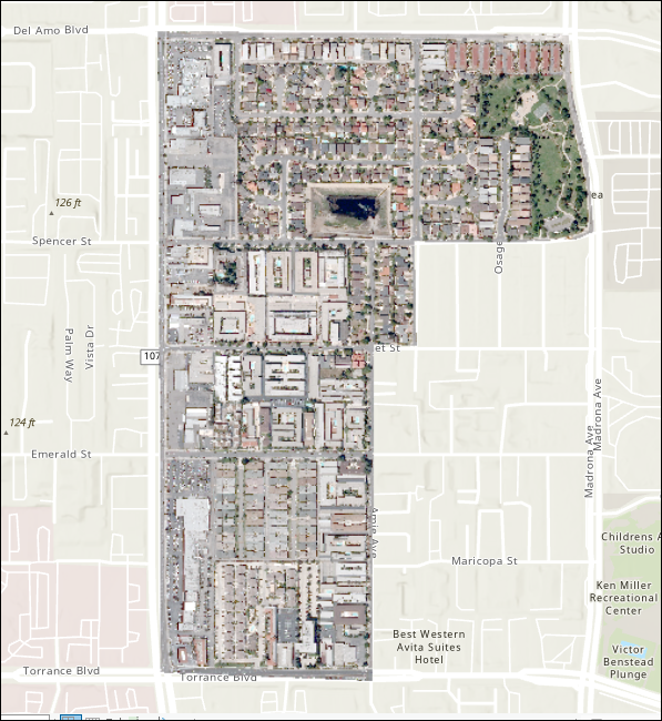
The image below shows the raster layer clipped to the polygon geometry while preserving the extent of the polygon feature layer.
Article ID: 000032806
- ArcGIS Pro 3 1
- ArcGIS Pro 3 3
- ArcGIS Pro 3 2
Get support with AI
Resolve your issue quickly with the Esri Support AI Chatbot.


Related Information
Discover more on this topic
Search for related information
Find training related to this topic
Explore ideas and give feedback
Get help from ArcGIS experts
Start chatting now