HOW TO
Calculate the number of times a street segment is traversed in a network analysis in ArcGIS Pro
Summary
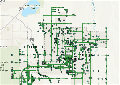
Network analysis optimizes interconnected systems such as transportation, utilities, and logistics by determining efficient routes, identifying service areas, or analyzing traffic. In ArcGIS Pro, a network and route dataset can be used to calculate the number of times a street segment is traversed in a network analysis. This technique involves splitting a long route into shorter segments and joining the unique ID field from the edge source attribute table with the split routes table. The unique ID field in the resulting spatial join table is then summarized to determine the number of times each edge is traversed, as shown in the image below.
Procedure
Note:
• Network datasets require a Network Analyst license.
• The Split Line at Point tool requires an ArcGIS Pro Advanced license.
- Open the project in ArcGIS Pro.
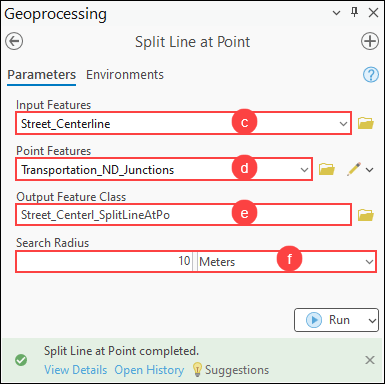
- Split the route layer into individual line segments using the Split Line at Point tool.
- On the Analysis tab, in the Geoprocessing group, click Tools.
- In the Geoprocessing pane, search for and click Split Line at Point (Data Management Tools).
- In the Split Line at Point pane, for Input Features, select the route layer from the drop-down list.
- For Point Features, select the junctions feature layer from the drop-down list.
- For Output Feature Class, specify a location and name for the output feature class.
- For Search Radius, specify a preferred distance for splitting the line based on its proximity and a unit of measurement. In this example, 10 meters is specified.
- Click Run.
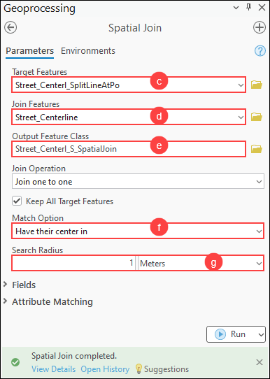
- Add the unique ID of the edge source feature class to the split routes layer using the Spatial Join tool.
- On the Analysis tab, in the Geoprocessing group, click Tools.
- In the Geoprocessing pane, search for and click Spatial Join (Analysis Tools).
- In the Spatial Join pane, for Target Features, select the output feature layer in Step 2 from the drop-down list.
- For Join Features, select the edge source feature layer from the drop-down list.
- For Output Feature Class, specify a name and location for the output feature layer.
- For Match Option, select Have their center in from the drop-down list.
- For Search Radius, specify a preferred distance for joining features within the radius and a unit of measurement. In this example, 1 meter is specified.
- Click Run.
Note:
Repeat Step 3 to add the unique IDs of any other edge source feature classes to the split route layer. Set the Target Features parameter to the output of the previous spatial join operation and the Join Features parameter to the next edge source feature class.
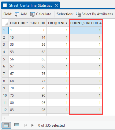
- Calculate the number of times a street segment is traversed in the attribute table.
- In the Contents pane, right-click the output feature layer in Step 3 and click Attribute Table.
- In the attribute table, right-click the unique ID field and click Summarize.
- In the Summary Statistics dialog box, under Statistics Fields, select the unique ID field from the drop-down list for Field, and select Count for Statistic Type.
- Click OK.
The output table below shows the number of times the street segment is traversed in the network analysis.
Article ID: 000034235
- ArcGIS Pro 3 3
- ArcGIS Pro 3 2
- ArcGIS Pro 3 4
Get support with AI
Resolve your issue quickly with the Esri Support AI Chatbot.


Related Information
Discover more on this topic
Search for related information
Find training related to this topic
Explore ideas and give feedback
Get help from ArcGIS experts
Start chatting now