A to Z GIS | Explore this related guide, featuring updated terms and graphics and developed in coordination with Esri’s GIS Dictionary team.
Learn more about A to Z GIS
GIS Dictionary
Browse dictionary
rubber sheeting
URL copiedShare URL
[data conversion]
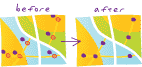
A procedure for adjusting the coordinates of all points in an image (raster) or feature (vector) dataset to align any identifiable points with known map locations. Layers are most closely aligned at the coincident (control) points, but due to nonuniform adjustments, variance between control points can cause map distortions. Rubber sheeting preserves the interconnectivity between points and objects through stretching, shrinking, or reorienting their interconnecting lines (in a feature dataset), or their neighboring pixels (in an image).