A to Z GIS | Explore this related guide, featuring updated terms and graphics and developed in coordination with Esri’s GIS Dictionary team.
Learn more about A to Z GIS
GIS Dictionary
Browse dictionary
quadtree
URL copiedShare URL
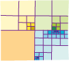
[data conversion]
A method for encoding raster data that reduces storage requirements and improves access speeds by storing values only for homogeneous regions rather than for every pixel. The raster is recursively subdivided into quadrants until all regions are homogeneous or until some specified level has been reached.