A to Z GIS | Explore this related guide, featuring updated terms and graphics and developed in coordination with Esri’s GIS Dictionary team.
Learn more about A to Z GIS
GIS Dictionary
Browse dictionary
overlay
URL copiedShare URL
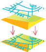
[spatial analysis]
A spatial operation in which two or more maps or layers registered to a common coordinate system are superimposed for the purpose of showing and analyzing the relationships between features that occupy the same geographic space.
[spatial analysis, data conversion]
In geoprocessing, the geometric intersection of multiple datasets to combine, erase, modify, update, or analyze features in a new output dataset.