A to Z GIS | Explore this related guide, featuring updated terms and graphics and developed in coordination with Esri’s GIS Dictionary team.
Learn more about A to Z GIS
GIS Dictionary
Browse dictionary
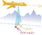
off-nadir
URL copiedShare URL
[remote sensing]
In satellite imagery, the number of degrees that the sensor varies from a vertical view when pointing directly downward from the platform. Also called angle of obliquity or elevation angle.
[photogrammetry]
In imagery, the angle between the vertical from the sensor's perspective center to a point directly below the optics—or nadir—and another point on the ground.