A to Z GIS | Explore this related guide, featuring updated terms and graphics and developed in coordination with Esri’s GIS Dictionary team.
Learn more about A to Z GIS
GIS Dictionary
Browse dictionary
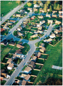
oblique photograph
URL copiedShare URL
[photogrammetry]
An aerial photograph taken with the axis of the camera held at an angle between the horizontal plane of the ground and the vertical plane perpendicular to the ground. A low oblique image shows only the surface of the earth; a high oblique image includes the horizon.