A to Z GIS | Explore this related guide, featuring updated terms and graphics and developed in coordination with Esri’s GIS Dictionary team.
Learn more about A to Z GIS
GIS Dictionary
Browse dictionary
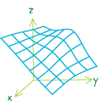
lattice
URL copiedShare URL
[data architecture]
A representation of a surface using an array of regularly spaced sample points (mesh points) that are referenced to a common origin and have a constant sampling distance in the x and y directions. Each mesh point contains the z-value at that location, which is referenced to a common base z-value, such as sea level. Z-values for locations between lattice mesh points can be approximated by interpolation based on neighboring mesh points.