A to Z GIS | Explore this related guide, featuring updated terms and graphics and developed in coordination with Esri’s GIS Dictionary team.
Learn more about A to Z GIS
GIS Dictionary
Browse dictionary
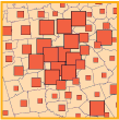
graduated symbol map
URL copiedShare URL
[thematic mapping]
A map with symbols that are scaled proportionately according to the value of the data attribute they represent; each data value is symbolized to show its location in the progression of smaller to larger data values. For example, denser populations might be represented by larger dots, or larger rivers by thicker lines.