A to Z GIS | Explore this related guide, featuring updated terms and graphics and developed in coordination with Esri’s GIS Dictionary team.
Learn more about A to Z GIS
GIS Dictionary
Browse dictionary
filter
URL copiedShare URL
[data architecture]
A constraint or set of constraints used to limit data to a subset. For example, in a map layer of global cities, set a filter to show only cities in Nigeria.
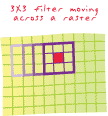
[spatial analysis]
On a raster, an analysis boundary or processing window within which cell values affect calculations and outside which they do not. Filters are used mainly in cell-based analysis where the value of a center cell is changed to the mean, the sum, or some other function of all cell values inside the filter.
[data architecture]
A GIS operation used to hide (but not delete) features in a map document or attribute table.