A to Z GIS | Explore this related guide, featuring updated terms and graphics and developed in coordination with Esri’s GIS Dictionary team.
Learn more about A to Z GIS
GIS Dictionary
Browse dictionary
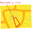
boundary line
URL copiedShare URL
[cartography, surveying]
A division between adjacent political entities, tracts of private land, or geographic zones on a map or survey. Boundary line typically refers to both the invisible border and the graphical representation of that line on the map. Boundary lines between privately owned land parcels are usually called property lines.