A to Z GIS | Explore this related guide, featuring updated terms and graphics and developed in coordination with Esri’s GIS Dictionary team.
Learn more about A to Z GIS
GIS Dictionary
Browse dictionary
anaglyph
URL copiedShare URL
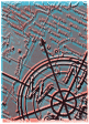
[image processing]
A stereo image that is created by superimposing two images of the same area. The images are displayed in complementary colors, usually red and blue or green. When viewed through filters of corresponding colors, the images appear as one 3D image. Anaglyphs are useful for visualizing terrain, elevation models, or other spatial data in 3D or virtual reality (VR) applications; they can provide a better understanding of the topography, spatial relationships, and features of the landscape.