A to Z GIS | Explore this related guide, featuring updated terms and graphics and developed in coordination with Esri’s GIS Dictionary team.
Learn more about A to Z GIS
GIS Dictionary
Browse dictionary
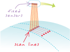
along-track scanner
URL copiedShare URL
[remote sensing]
Also known as a push broom sensor. In satellite imagery, a sensor that uses a linear array in the focal plane to create an image by moving that array through space. The linear, projected footprint of the array is perpendicular to the sensor's movement.