操作方法
操作方法:在 ArcMap 中符号化非空间表格数据或相关数据
描述
表格数据对于提供要素图层的附加属性信息非常有用。 虽然包含地理信息(经纬度)的表格数据可以使用显示 XY 数据功能在地图上显示,但不含地理信息的表格数据则可以通过执行连接操作或使用创建查询表工具与包含地理信息的要素图层相关联。
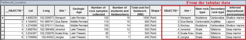
在本示例中,展示了马来西亚半岛中部一次野外考察的详细信息。 下图显示了来自要素图层和非空间表格数据的数据。
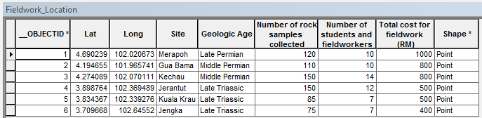
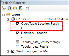
名为 Fieldwork_Location 的要素图层包含纬度和经度形式的地理信息。 其他字段包括 Site、Geologic Age、Number of rock samples collected、Number of students and fieldworkers、Total cost for fieldwork (RM) 和 Shape。 Site 字段用于与非空间表格数据建立关系。
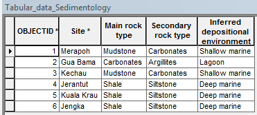
名为 Tabular_data_Sedimentology 的非空间表格数据包含以下字段:Site、Main rock type、Secondary rock type 以及 Inferred depositional environment。 Site 字段是该表格数据与要素图层之间构成一对一关系的共同属性。
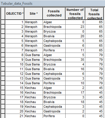
名为 Tabular_data_Fossils 的非空间表格数据包含以下字段:Site、Fossils collected、Number of fossils collected 以及 Total fossils collected。 Site 字段与要素图层中的 Site 字段为一对多关系,并且是表格数据和要素图层之间的共同属性。
解决方案或解决方法
(要素图层):(表格数据)具有一对一 (1:1) 关系
当非空间表格数据与要素图层存在一对一关系时,应先执行连接操作,然后再对连接后的数据进行符号化。 有关详细信息,请参阅连接表的基础知识和管理连接表。
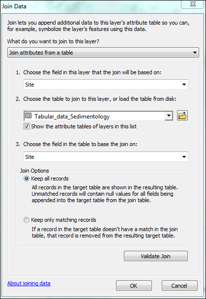
- 在 ArcMap 中,导航至目标要素图层,并将其与所需的表格数据创建连接。 遵循将一个表中的属性连接到另一个表文档中所述的步骤。 在本例中,Fieldwork_Location 要素图层通过共同字段 Site 与 Tabular_data_Sedimentology 表格数据进行连接。
要素图层的属性表将显示从表格数据连接而来的信息。
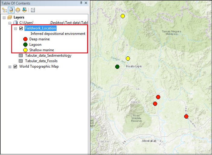
- 对要素图层进行符号化。 右键单击该要素图层,选择属性 > 符号系统。 从表格数据连接而来的属性会包含在值字段的下拉列表中。 在本例中,要素图层基于从表格数据获取的属性(即推断沉积环境)进行符号化。
(要素图层):(表格数据)具有一对多 (1:M) 关系
在 ArcMap 中,一对多 (1:M) 或多对多 (M:M) 关系通常通过在要素图层和表格数据之间创建关联来建立。 然而,也可以使用创建查询表工具将非空间表格数据与要素图层按一对多关系进行连接。 有关详细信息,请参阅 操作方法:在 ArcMap 中创建一对多连接。
Note:
For this method, the following caveats must be noted.
• Use non-spatial tabular data stored within a geodatabase or database connection
• Symbolize related data up to a second-level nested relationship
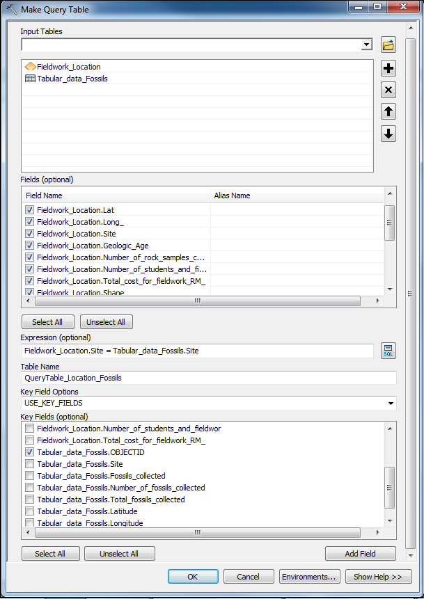
- 在 ArcMap 中,单击搜索
 ,然后搜索创建查询表工具。
 - 在创建查询表对话框中:
- 对于输入字段,选择要连接的要素图层和表格数据。 在本例中,它们是 Fieldwork_Location 和 Tabular_data_Fossils。
- 对于字段,选择希望出现在输出表中的字段。
Note:
Include the Shape field in the selection to create a temporary layer output. Otherwise, a table view is returned.
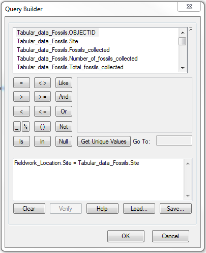
- 对于表达式,单击 SQL 图标
 。 在查询构建器对话框中,构建表达式以指定记录子集,然后单击确定。 在本例中,要素图层中的 Site 字段等于表格数据中的 Site 字段。 在查询构建器中,表达式为:Fieldwork_Location.Site=Tabular_data_Fossils.Site。 单击确定。
- 对于名称,指定输出表的名称。
- 对于关键字字段选项,选择 USE_KEY_FIELDS。
- 对于关键字段,指定能够唯一标识一行的字段。 在本例中,使用的是表格数据的 OBJECTID,即 Tabular_data_Fossils_OBJECTID。
- 单击确定。
一个临时图层将被创建并显示在内容列表中。
Note:
The temporary layer created remains in Table Of Contents if the document is saved before ArcMap is closed. However, the layer is not stored in the geodatabase, so it is not available for other projects. To create a permanent feature class, use methods such as exporting the data or the Copy Features tool. Alternatively, use the Save To Layer File tool to create a layer file.
- 创建永久要素类。 在本例中,使用的是复制要素工具。 一个要素类将被添加到地理数据库和内容列表中。
- 对要素图层进行符号化。 右键单击该要素图层,选择属性 > 符号系统 > 多个属性。 有关详细信息,请参阅操作方法:根据多个属性值对点进行符号化。 配置符号系统。
- 对于值字段,选择表格数据中与共同字段构成一对多关系的原始字段。 在本例中,选择的是 Fossils collected 字段。 对于列出的每个站点(要素图层与表格数据间的共同字段),均分析了七种化石类型。
- 取消选中 <所有其他值> 并选择 添加所有值。
- 对于变化依据,选择色带 或符号大小。
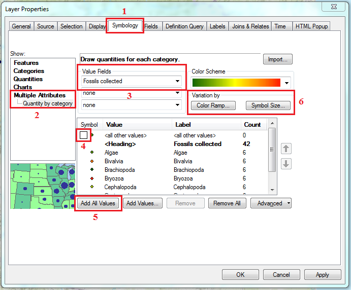
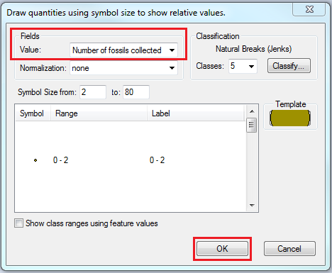
- 对于所选类别的值字段,选择次要变量,对步骤 4a 中指定的主要变量(相关数据)进行符号化。 在本例中,选择了符号大小类别,并使用 Number of fossils collected 作为次要变量。
Note:
For the Variation by field, only integer fields are listed in the Value field drop-down. So, it is possible to symbolize related data only with a numeric variable.
- 如有必要,指定其他可选字段,如符号大小和类。 单击确定。
- 单击确定。
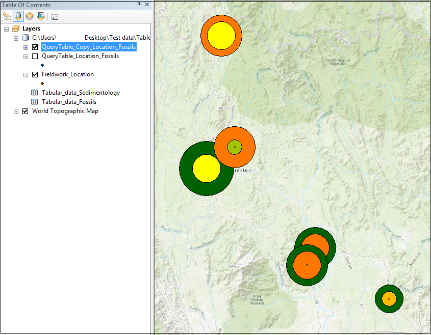
下图显示了基于 Number of fossils collected 对关联数据(采集的化石)进行符号化的效果。 化石的类型通过颜色区分,而采集的化石数量则通过大小区分。
Note:
In ArcGIS Online, it is possible to symbolize related data by creating a one-to-many join using Join Features between a feature layer and non-spatial tabular data, and symbolizing the output join layer using the Types and Size symbology.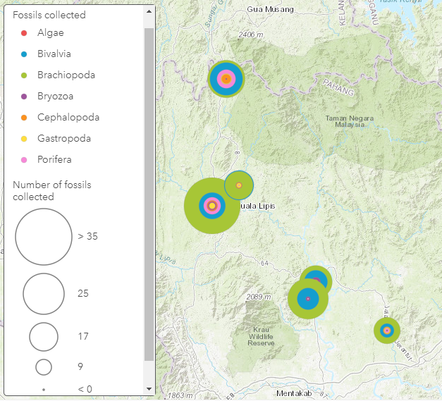
文章 ID: 000022371
获得人工智能支持
使用 Esri Support AI Chatbot 快速解决您的问题。


相关信息
发现关于本主题的更多内容
Search for related information
Find training related to this topic
Explore ideas and give feedback
获取来自 ArcGIS 专家的帮助
立即开始聊天