固定对话栏 | 支持 | GIS 词典
A 到 Z 的 GIS |
探索这份相关指南,其中包含更新的术语和图形,并由 Esri 的 GIS 词典团队协作开发。
了解更多关于 A 到 Z 的 GIS 知识
GIS 字典
浏览字典
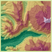
分层设色
URL 已复制
共享 URL
[可视化技术]
一种在等值线之间添加颜色以说明高程深度变化的方法。 每种颜色代表不同的高程范围。 也称为图层设色或分层着色。
另请参阅
等值线
高程